
Topografische kaart Magothy River
Interactieve kaart
Klik op de kaart om de hoogte weer te geven.
Over deze kaart
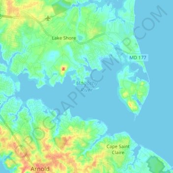
Naam: Topografische kaart Magothy River, hoogte, reliëf.
Gemiddelde hoogte: 9 m
Minimale hoogte: -3 m
Maximale hoogte: 46 m
Almost all of the creeks and tidal coves on the Magothy are named, partly as the result of a project started in 2001 by the Magothy River Association. They are shown on a map produced as part of that project, and the major ones are shown on the USGS topographic map.
Andere topografische kaarten
Klik op een kaart om zijn topografie, zijn hoogte en zijn reliëf te bekijken.
Magothy Forest
United States > Maryland > Anne Arundel County > Severna Park
Magothy Forest, Severna Park, Anne Arundel County, Maryland, 21146, United States
Gemiddelde hoogte: 13 m
Longmeadow North
United States > Maryland > Anne Arundel County > Severna Park
Longmeadow North, Severna Park, Anne Arundel County, Maryland, 21146, United States
Gemiddelde hoogte: 8 m
Linstead-on-the-Severn
United States > Maryland > Anne Arundel County > Severna Park
Linstead-on-the-Severn, Severna Park, Anne Arundel County, Maryland, 21146, United States
Gemiddelde hoogte: 11 m
Severndale
United States > Maryland > Anne Arundel County > Severna Park > Severndale
Severndale, Severna Park, Anne Arundel County, Maryland, 22146, United States
Gemiddelde hoogte: 18 m
Windrush Farm
United States > Maryland > Anne Arundel County > Severna Park > Windrush Farm
Windrush Farm, Severna Park, Anne Arundel County, Maryland, 21012, United States
Gemiddelde hoogte: 10 m
Lower Magothy Beach
United States > Maryland > Anne Arundel County > Severna Park > Lower Magothy Beach
Lower Magothy Beach, Severna Park, Anne Arundel County, Maryland, 21122, United States
Gemiddelde hoogte: 9 m