
Topografische kaart Balut Island
Interactieve kaart
Klik op de kaart om de hoogte weer te geven.
Over deze kaart
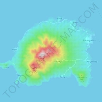
Naam: Topografische kaart Balut Island, hoogte, reliëf.
Gemiddelde hoogte: 87 m
Minimale hoogte: 0 m
Maximale hoogte: 827 m
Balut Island, the westernmost of the Sarangani Islands, is the larger, higher, and better cultivated than Sarangani Island. In the center of the island is Balut Volcano, which is fumarolic on occasion. Balut Island rises to about 1,800 metres (5,900 ft) from the seabed with the highest elevation at 862 metres (2,828 ft) above mean sea level. Base diameter of the island is 8 kilometres (5.0 mi).
Andere topografische kaarten
Klik op een kaart om zijn topografie, zijn hoogte en zijn reliëf te bekijken.
Sarangani
Philippines > Davao Occidental > Sarangani
Sarangani, Davao Occidental, Davao Region, Philippines
Gemiddelde hoogte: 13 m