
Topografische kaart Norwalk
Interactieve kaart
Klik op de kaart om de hoogte weer te geven.
Over deze kaart
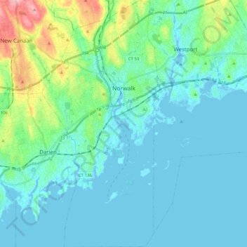
Naam: Topografische kaart Norwalk, hoogte, reliëf.
Locatie: Norwalk, Fairfield County, Connecticut, United States (41.02045 -73.47457 41.17127 -73.38029)
Gemiddelde hoogte: 24 m
Minimale hoogte: -7 m
Maximale hoogte: 145 m
Norwalk's topography is dominated by its coastline along Long Island Sound, the Norwalk River and its eastern and western banks, and the Norwalk Islands. The highest elevation is 315 feet (96 m) above sea level on the fairway of the 16th hole of the Silvermine Golf Course, and the low elevation is sea level on Long Island Sound.