
Topografische kaart Sebastopol
Interactieve kaart
Klik op de kaart om de hoogte weer te geven.
Sebastopol
Sebastopol's elevation is 65 to 250 feet (20 to 76 meters) above sea level. Its downtown is at the intersection of State Route 12 and State Route 116 (Gravenstein Highway), approximately 9 mi (14 km) west of U.S. Route 101.
Over deze kaart
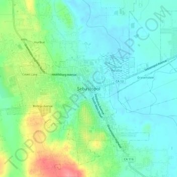
Naam: Topografische kaart Sebastopol, hoogte, reliëf.
Gemiddelde hoogte: 41 m
Minimale hoogte: 14 m
Maximale hoogte: 108 m