
Doe een donatie
Rust jezelf uit voor je volgende avontuur:
Als Amazon-partner verdient deze site een commissie op in aanmerking komende aankopen, zonder extra kosten voor jou.
Topografische kaart Madau
Klik op de kaart om de hoogte weer te geven.
Doe een donatie
Rust jezelf uit voor je volgende avontuur:
Als Amazon-partner verdient deze site een commissie op in aanmerking komende aankopen, zonder extra kosten voor jou.
Over deze kaart
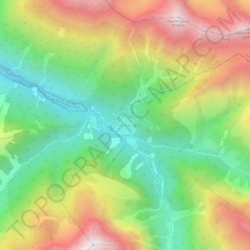
Naam: Topografische kaart Madau, hoogte, reliëf.
Locatie: Madau, Zams, Bezirk Landeck, Tyrol, 6511, Austria (47.21354 10.43246 47.25354 10.47246)
Gemiddelde hoogte: 1.780 m
Minimale hoogte: 1.169 m
Maximale hoogte: 2.589 m
Doe een donatie
Rust jezelf uit voor je volgende avontuur:
Als Amazon-partner verdient deze site een commissie op in aanmerking komende aankopen, zonder extra kosten voor jou.
Andere topografische kaarten
Klik op een kaart om zijn topografie, zijn hoogte en zijn reliëf te bekijken.
Ischgl
Austria > Tyrol > Bezirk Landeck
Ischgl has a weather station at an altitude of 2,327 m (7,635 ft). This weather station is located within the alpine climate zone (Köppen ETH), closely bordering on a subarctic climate (Köppen Dfc), because the hottest month is only 9.9 °C (49.8 °F).
Gemiddelde hoogte: 2.251 m
Doe een donatie
Rust jezelf uit voor je volgende avontuur:
Als Amazon-partner verdient deze site een commissie op in aanmerking komende aankopen, zonder extra kosten voor jou.
Doe een donatie
Rust jezelf uit voor je volgende avontuur:
Als Amazon-partner verdient deze site een commissie op in aanmerking komende aankopen, zonder extra kosten voor jou.
Nauders
Austria > Tyrol > Bezirk Landeck
The town lies in the valley of the Stillebach (a tributary of the Inn) in the Ötztal Alps, at an altitude of 1,394 m (4,573 ft). It is located about 29 km (18 mi) south of the district capital Landeck, on the road that leads from Pfunds in the Inntal valley via the narrow Finstermünz Gorge up to Reschen Pass…
Gemiddelde hoogte: 1.938 m
Ischgl
Austria > Tyrol > Bezirk Landeck
Ischgl has a weather station at an altitude of 2,327 m (7,635 ft). This weather station is located within the alpine climate zone (Köppen ETH), closely bordering on a subarctic climate (Köppen Dfc), because the hottest month is only 9.9 °C (49.8 °F).
Gemiddelde hoogte: 2.251 m
Doe een donatie
Rust jezelf uit voor je volgende avontuur:
Als Amazon-partner verdient deze site een commissie op in aanmerking komende aankopen, zonder extra kosten voor jou.
Kaunertal
Austria > Tyrol > Bezirk Landeck
The Kaunertal valley is 28 km (17 mi) in length and runs southeast from the town of Prutz (884 m) to the Kaunertal Glacier. The valley is traversed by the Faggenbach river, which rises south of the Weißseespitze mountain (3044 m) and flows into the Inn river at Prutz (884 m), the site of a hydroelectric power…
Gemiddelde hoogte: 2.399 m
Doe een donatie
Rust jezelf uit voor je volgende avontuur:
Als Amazon-partner verdient deze site een commissie op in aanmerking komende aankopen, zonder extra kosten voor jou.
Nauders
Austria > Tyrol > Bezirk Landeck
The town lies in the valley of the Stillebach (a tributary of the Inn) in the Ötztal Alps, at an altitude of 1,394 m (4,573 ft). It is located about 29 km (18 mi) south of the district capital Landeck, on the road that leads from Pfunds in the Inntal valley via the narrow Finstermünz Gorge up to Reschen Pass…
Gemiddelde hoogte: 1.938 m
Ischgl
Austria > Tyrol > Bezirk Landeck
Ischgl has a weather station at an altitude of 2,327 m (7,635 ft). This weather station is located within the alpine climate zone (Köppen ETH), closely bordering on a subarctic climate (Köppen Dfc), because the hottest month is only 9.9 °C (49.8 °F).
Gemiddelde hoogte: 2.251 m
Doe een donatie
Rust jezelf uit voor je volgende avontuur:
Als Amazon-partner verdient deze site een commissie op in aanmerking komende aankopen, zonder extra kosten voor jou.