
Topografische kaart Alexandria
Interactieve kaart
Klik op de kaart om de hoogte weer te geven.
Over deze kaart
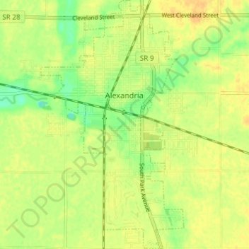
Naam: Topografische kaart Alexandria, hoogte, reliëf.
Locatie: Alexandria, Madison County, Indiana, 46001, United States (40.23399 -85.69635 40.28065 -85.66118)
Gemiddelde hoogte: 268 m
Minimale hoogte: 251 m
Maximale hoogte: 278 m
Andere topografische kaarten
Klik op een kaart om zijn topografie, zijn hoogte en zijn reliëf te bekijken.
Elwood
United States > Indiana > Madison County
Elwood, Madison County, Indiana, 46036, United States
Gemiddelde hoogte: 264 m
Hillcrest
United States > Indiana > Madison County > Anderson
Hillcrest, Anderson, Madison County, Indiana, 46016, United States
Gemiddelde hoogte: 269 m
Mounds State Park
United States > Indiana > Madison County > Anderson
Mounds State Park, Anderson, Madison County, Indiana, United States
Gemiddelde hoogte: 276 m
Frankton
United States > Indiana > Madison County > Frankton
Frankton, Madison County, Indiana, United States
Gemiddelde hoogte: 259 m