
Topografische kaart Rainier
Interactieve kaart
Klik op de kaart om de hoogte weer te geven.
Over deze kaart
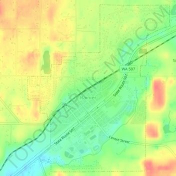
Naam: Topografische kaart Rainier, hoogte, reliëf.
Locatie: Rainier, Thurston County, Washington, 98576, United States (46.87966 -122.70292 46.90530 -122.67109)
Gemiddelde hoogte: 143 m
Minimale hoogte: 113 m
Maximale hoogte: 173 m
Andere topografische kaarten
Klik op een kaart om zijn topografie, zijn hoogte en zijn reliëf te bekijken.
Olympia
United States > Washington > Thurston County
Olympia, Thurston County, Washington, United States
Gemiddelde hoogte: 49 m
Yelm
United States > Washington > Thurston County
Yelm, Thurston County, Washington, 98956, United States
Gemiddelde hoogte: 107 m
Lacey
United States > Washington > Thurston County
Lacey, Thurston County, Washington, United States
Gemiddelde hoogte: 47 m
Boston Harbor
United States > Washington > Thurston County
Boston Harbor, Thurston County, Washington, United States
Gemiddelde hoogte: 13 m
North Yelm
United States > Washington > Thurston County
North Yelm, Thurston County, Washington, United States
Gemiddelde hoogte: 95 m
Tenino
United States > Washington > Thurston County
Tenino, Thurston County, Washington, United States
Gemiddelde hoogte: 131 m
Lemon Hill
United States > Washington > Thurston County
Lemon Hill, Thurston County, Washington, 98589, United States
Gemiddelde hoogte: 123 m
Tumwater
United States > Washington > Thurston County
Tumwater, Thurston County, Washington, United States
Gemiddelde hoogte: 58 m
Lacey
United States > Washington > Thurston County > Lacey > Lacey
Lacey, Thurston County, Washington, 98503, United States
Gemiddelde hoogte: 59 m
Rochester
United States > Washington > Thurston County > Rochester
Rochester, Thurston County, Washington, United States
Gemiddelde hoogte: 50 m