
Topografische kaart Cagayancillo
Interactieve kaart
Klik op de kaart om de hoogte weer te geven.
Over deze kaart
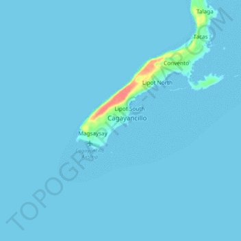
Naam: Topografische kaart Cagayancillo, hoogte, reliëf.
Locatie: Cagayancillo, Palawan, Mimaropa, 5321, Philippines (9.53691 121.15715 9.61691 121.23715)
Gemiddelde hoogte: 2 m
Minimale hoogte: 0 m
Maximale hoogte: 61 m
There are neither mountain ranges nor forested areas in the municipality. A hilly portion in the north-eastern part of the main island has a slope of 3-82%. The other areas are flat with the highest elevation around 2 to 3 meters. The majority of the island has a sandy loam soil not enough to support a forest.