
Topografische kaart Yongfu County
Interactieve kaart
Klik op de kaart om de hoogte weer te geven.
Over deze kaart
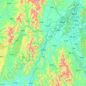
Naam: Topografische kaart Yongfu County, hoogte, reliëf.
Locatie: Yongfu County, Guilin, Guangxi, China (24.64826 109.61164 25.44246 110.23691)
Gemiddelde hoogte: 344 m
Minimale hoogte: 101 m
Maximale hoogte: 1.361 m
Yongfu County (Chinese: 永福县; pinyin: Yǒngfú Xiàn) is a county under the administration of the prefecture-level city of Guilin, Guangxi, China, located 55 km (34 mi) to the southwest of downtown Guilin. The county is mostly rural and hilly, marked by the same dramatic karst topography for which Guilin is famous.