
Topografische kaart Beacon Rock
Klik op de kaart om de hoogte weer te geven.
Over deze kaart
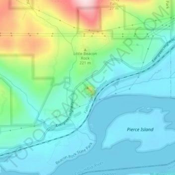
Naam: Topografische kaart Beacon Rock, hoogte, reliëf.
Gemiddelde hoogte: 93 m
Minimale hoogte: -1 m
Maximale hoogte: 386 m
Andere topografische kaarten
Klik op een kaart om zijn topografie, zijn hoogte en zijn reliëf te bekijken.
Gifford Pinchot National Forest
United States > Washington > Skamania County
Gifford Pinchot National Forest is located in a mountainous region approximately between Mount St. Helens to the west, Mount Adams to the east, Mount Rainier National Park to the north, and the Columbia River to the south. This region of Southwest Washington is noted for its complex topography and volcanic…
Gemiddelde hoogte: 769 m
Spirit Lake
United States > Washington > Skamania County
Prior to 1980, Spirit Lake consisted of two arms that occupied what had been the valleys of the North Fork Toutle River and a tributary. About 4,000 years ago, these valleys were blocked by lahars and pyroclastic flow deposits from Mount St. Helens to form the pre-1980 Spirit Lake. The longest branch of Spirit…
Gemiddelde hoogte: 1.144 m