
Topografische kaart Balmoral
Interactieve kaart
Klik op de kaart om de hoogte weer te geven.
Over deze kaart
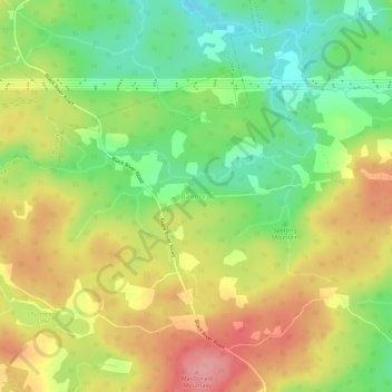
Naam: Topografische kaart Balmoral, hoogte, reliëf.
Gemiddelde hoogte: 55 m
Minimale hoogte: 1 m
Maximale hoogte: 112 m
Andere topografische kaarten
Klik op een kaart om zijn topografie, zijn hoogte en zijn reliëf te bekijken.
Flat Rock
Canada > Nova Scotia > Municipality of the County of Richmond > Grand River
Flat Rock, Grand River, Municipality of the County of Richmond, Richmond County, Nova Scotia, Canada
Gemiddelde hoogte: 5 m
Cleveland
Canada > Nova Scotia > Municipality of the County of Richmond
Cleveland, Municipality of the County of Richmond, Richmond County, Nova Scotia, Canada
Gemiddelde hoogte: 40 m
Point Michaud
Canada > Nova Scotia > Municipality of the County of Richmond
Point Michaud, Municipality of the County of Richmond, Richmond County, Nova Scotia, Canada
Gemiddelde hoogte: 12 m
Louisdale
Canada > Nova Scotia > Municipality of the County of Richmond
Louisdale, Municipality of the County of Richmond, Richmond County, Nova Scotia, B0E 1V0, Canada
Gemiddelde hoogte: 26 m