
Topografische kaart Mountain Village
Interactieve kaart
Klik op de kaart om de hoogte weer te geven.
Over deze kaart
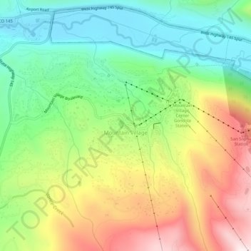
Naam: Topografische kaart Mountain Village, hoogte, reliëf.
Gemiddelde hoogte: 2.917 m
Minimale hoogte: 2.629 m
Maximale hoogte: 3.341 m
Mountain Village is a home rule municipality in San Miguel County, southwestern Colorado. It is located just southwest of Telluride, Colorado in the San Juan Mountains. The elevation of the town rises above Telluride to 9,600 feet. The population was 1,264 at the 2020 census.
Andere topografische kaarten
Klik op een kaart om zijn topografie, zijn hoogte en zijn reliëf te bekijken.
Telluride
United States > Colorado > San Miguel County
Telluride, San Miguel County, Colorado, 81435, United States
Gemiddelde hoogte: 3.125 m
Noel
United States > Colorado > San Miguel County
Noel, San Miguel County, Colorado, United States
Gemiddelde hoogte: 2.774 m
Pandora
United States > Colorado > San Miguel County > Pandora
Pandora, San Miguel County, Colorado, 81435, United States
Gemiddelde hoogte: 3.174 m
Telluride
United States > Colorado > San Miguel County > Telluride
Telluride, San Miguel County, Colorado, 8145, United States
Gemiddelde hoogte: 3.246 m
Imogene Pass
United States > Colorado > San Miguel County
Imogene Pass, San Miguel County, Colorado, 81231, United States
Gemiddelde hoogte: 3.837 m
Telluride Peak
United States > Colorado > San Miguel County
Telluride Peak, San Miguel County, Colorado, 81231, United States
Gemiddelde hoogte: 3.843 m