
Topografische kaart Chalmette
Interactieve kaart
Klik op de kaart om de hoogte weer te geven.
Chalmette
Chalmette is located at 29°56′44″N 89°57′42″W / 29.94556°N 89.96167°W / 29.94556; -89.96167 (29.945504, -89.961602), along the Mississippi River and has an elevation of 3 feet (0.9 m). It is located east of New Orleans, and is part of the Greater New Orleans area. According to the United States Census Bureau, the CDP has a total area of 7.9 square miles (20 km2), of which 7.3 square miles (19 km2) is land, and 0.6 square miles (1.6 km2) (7.56%) is water.
Over deze kaart
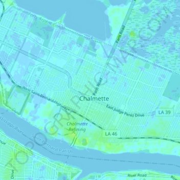
Naam: Topografische kaart Chalmette, hoogte, reliëf.
Gemiddelde hoogte: 1 m
Minimale hoogte: -4 m
Maximale hoogte: 11 m