
Topografische kaart Reef Canyon
Interactieve kaart
Klik op de kaart om de hoogte weer te geven.
Over deze kaart
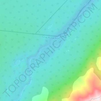
Naam: Topografische kaart Reef Canyon, hoogte, reliëf.
Gemiddelde hoogte: 1.107 m
Minimale hoogte: 922 m
Maximale hoogte: 2.152 m
Andere topografische kaarten
Klik op een kaart om zijn topografie, zijn hoogte en zijn reliëf te bekijken.
Black Bear Ridge
Canada > British Columbia > Peace River Regional District > Area B (Finlay Valley/Beatton Valley)
Black Bear Ridge, Area B (Finlay Valley/Beatton Valley), Peace River Regional District, British Columbia, Canada
Gemiddelde hoogte: 1.314 m
Budd Lake
Canada > British Columbia > Peace River Regional District > Area B (Finlay Valley/Beatton Valley)
Budd Lake, Area B (Finlay Valley/Beatton Valley), Peace River Regional District, British Columbia, Canada
Gemiddelde hoogte: 1.124 m