
Topografische kaart Fremont
Interactieve kaart
Klik op de kaart om de hoogte weer te geven.
Over deze kaart
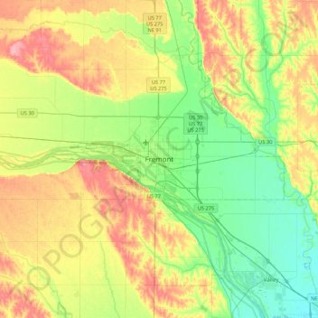
Naam: Topografische kaart Fremont, hoogte, reliëf.
Locatie: Fremont, Dodge County, Nebraska, 68025, United States (41.27384 -96.65604 41.59384 -96.33604)
Gemiddelde hoogte: 378 m
Minimale hoogte: 340 m
Maximale hoogte: 434 m
According to the United States Census Bureau, the city has a total area of 8.85 square miles (22.92 km2), of which 8.80 square miles (22.79 km2) is land and 0.05 square miles (0.13 km2) is water. Fremont lies in the river plain between the Platte and Elkhorn rivers, at an elevation of approximately 366 meters (1,203 ft) above sea level.