
Topografische kaart Nowshera
Interactieve kaart
Klik op de kaart om de hoogte weer te geven.
Over deze kaart
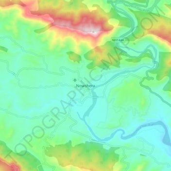
Naam: Topografische kaart Nowshera, hoogte, reliëf.
Gemiddelde hoogte: 668 m
Minimale hoogte: 501 m
Maximale hoogte: 1.119 m
Given its spatial and demographic extent, Nowshera has been given the status of a Sub-District. It is a beautiful place with a number of tourist attractions including the fort of Mangla Devi, holy cave temple of Mangla Mata, Central Gurudwara of Sikhs in Nonial, Qila Darhal and other Dargahs and temples. The literacy rate of Nowshera is very high with low male-female literacy gap that shows that there is deep inclination of people towards education. It has an average elevation of 1,575 metres (5,167 feet).
Andere topografische kaarten
Klik op een kaart om zijn topografie, zijn hoogte en zijn reliëf te bekijken.
baganoti
India > Jammu and Kashmir > Nowshehra Tehsil
baganoti, Nowshehra Tehsil, Rajouri District, Jammu and Kashmir, India
Gemiddelde hoogte: 636 m