
Topografische kaart Hadleigh
Klik op de kaart om de hoogte weer te geven.
Over deze kaart
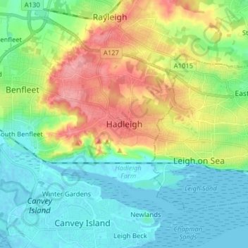
Naam: Topografische kaart Hadleigh, hoogte, reliëf.
Locatie: Hadleigh, Castle Point, Essex, England, SS7 2RD, United Kingdom (51.51392 0.56870 51.59392 0.64870)
Gemiddelde hoogte: 29 m
Minimale hoogte: -1 m
Maximale hoogte: 87 m
Andere topografische kaarten
Klik op een kaart om zijn topografie, zijn hoogte en zijn reliëf te bekijken.
Canvey Island
United Kingdom > England > Essex > Castle Point > Canvey
In 1607 the Elizabethan antiquarian William Camden noted in his work Britannia (a topographical and historical survey of all of Great Britain and Ireland) that Canvey Island (which he called Island Convennon) was documented in the 2nd century by the Alexandrian geographer Ptolemy. In his work Geographia,…
Gemiddelde hoogte: 10 m
Canvey Island
United Kingdom > England > Essex > Castle Point > Canvey Island
In 1607 the Elizabethan antiquarian William Camden noted in his work Britannia (a topographical and historical survey of all of Great Britain and Ireland) that Canvey Island (which he called Island Convennon) was documented in the 2nd century by the Alexandrian geographer Ptolemy. In his work Geographia,…
Gemiddelde hoogte: 10 m