
Topografische kaart Jaglot
Interactieve kaart
Klik op de kaart om de hoogte weer te geven.
Over deze kaart
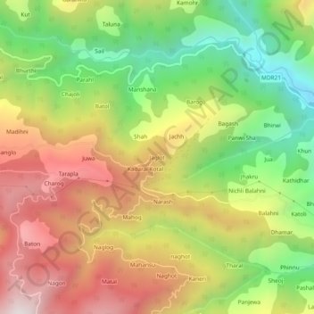
Naam: Topografische kaart Jaglot, hoogte, reliëf.
Gemiddelde hoogte: 1.653 m
Minimale hoogte: 1.089 m
Maximale hoogte: 2.252 m
Andere topografische kaarten
Klik op een kaart om zijn topografie, zijn hoogte en zijn reliëf te bekijken.
Rohai
India > Himachal Pradesh > Karsog > Pangna
Rohai, Pangna, Karsog, Mandi, Himachal Pradesh, 175046, India
Gemiddelde hoogte: 1.619 m
Jaglot
India > Himachal Pradesh > Karsog
Jaglot, Karsog, Mandi, Himachal Pradesh, 175011, India
Gemiddelde hoogte: 1.659 m
Sunni
India > Himachal Pradesh > Karsog > Sunni
Sunni, Karsog, Mandi, Himachal Pradesh, India
Gemiddelde hoogte: 768 m