
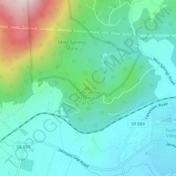
Topografische kaart Little Yellow Mountain
Interactieve kaart
Klik op de kaart om de hoogte weer te geven.
Over deze kaart
Naam: Topografische kaart Little Yellow Mountain, hoogte, reliëf.
Gemiddelde hoogte: 345 m
Minimale hoogte: 214 m
Maximale hoogte: 773 m
Andere topografische kaarten
Klik op een kaart om zijn topografie, zijn hoogte en zijn reliëf te bekijken.
Williamsburg
USA > Virginia > Williamsburg
Williamsburg, Williamsburg (city), Virginia, 23185, USA
Gemiddelde hoogte: 22 m
Great Dismal Swamp
Great Dismal Swamp, West Ditch Trail, Suffolk, Virginia, USA
Gemiddelde hoogte: 11 m
First Landing State Park
USA > Virginia > Virginia Beach
First Landing State Park, Virginia Beach, Virginia, USA
Gemiddelde hoogte: 3 m
James River
James River, Henrico County, Virginia, 23219:23223, USA
Gemiddelde hoogte: 89 m
Nansemond River
Nansemond River, Suffolk, Virginia, 23434, USA
Gemiddelde hoogte: 9 m
Bush Mountain
USA > Virginia > Harrisonburg
Bush Mountain, Harrisonburg, Rockingham County, Virginia, USA
Gemiddelde hoogte: 634 m
Burke Lake Park
USA > Virginia > Avon Forest
Burke Lake Park, Belleair, Avon Forest, Fairfax County, Virginia, USA
Gemiddelde hoogte: 104 m
West Point
USA > Virginia > West Point
West Point, King William County, Virginia, 23110, USA
Gemiddelde hoogte: 4 m
Shenandoah River
Shenandoah River, Clarke County, Virginia, 25432, USA
Gemiddelde hoogte: 197 m
Kiptopeke State Park
USA > Virginia > Cedar Grove
Kiptopeke State Park, Cedar Grove, Northampton County, Virginia, USA
Gemiddelde hoogte: 6 m
Black Rock Mountain
Black Rock Mountain, Nelson County, Virginia, 22958, USA
Gemiddelde hoogte: 817 m
White Oak Mountain
White Oak Mountain, Pittsylvania County, Virginia, USA
Gemiddelde hoogte: 248 m
Beechwood Shores
USA > Virginia > Beechwood Shores
Beechwood Shores, Bedford County, Virginia, 24121, USA
Gemiddelde hoogte: 262 m
Buffalo Springs
USA > Virginia > Buffalo Springs
Buffalo Springs, Nelson County, Virginia, 24553, USA
Gemiddelde hoogte: 178 m
North Camellia Acres
USA > Virginia > Norfolk > North Camellia Acres
North Camellia Acres, Norfolk, Virginia, 23518, USA
Gemiddelde hoogte: 3 m
Franklin City
USA > Virginia > Franklin City
Franklin, Franklin City, Virginia, 23851, USA
Gemiddelde hoogte: 12 m
Southwood Estates Mobile Home Park
USA > Virginia > Southwood Estates Mobile Home Park
Southwood Estates Mobile Home Park, Albemarle County, Virginia, 22902-8706, USA
Gemiddelde hoogte: 156 m
Powhatan Courthouse Historic District
Powhatan Courthouse Historic District, Powhatan, Powhatan County, Virginia, 23139, USA
Gemiddelde hoogte: 106 m
Lake Haven
USA > Virginia > Lake Haven
Lake Haven, Bedford County, Virginia, 23137, USA
Gemiddelde hoogte: 248 m
Fort Harrison
USA > Virginia > Varina Gardens
Fort Harrison, Varina, Varina Gardens, Henrico County, Virginia, USA
Gemiddelde hoogte: 34 m
Bethel Beach
USA > Virginia > Haven Beach
Bethel Beach, State Route 720, Haven Beach, Mathews County, Virginia, 23045, USA
Gemiddelde hoogte: 1 m
Whitetop Mountain
Whitetop Mountain, Grayson County, Virginia, 24292, USA
Gemiddelde hoogte: 1.426 m
Occoquan Bay
USA > Virginia > Pohick Park Estates
Occoquan Bay, High Point Road, Pohick Park Estates, Fairfax County, Virginia, 22191, USA
Gemiddelde hoogte: 3 m
Government Island
Government Island, Aquia Harbour, Stafford County, Virginia, 22554, USA
Gemiddelde hoogte: 58 m
Parramore Island
Parramore Island, Accomack County, Virginia, USA
Gemiddelde hoogte: 1 m
Kempsville Lake Park
USA > Virginia > Virginia Beach > Powell's Crossroads
Kempsville Lake Park, Kempsville Gardens, Kempsville, Powell's Crossroads, Virginia Beach, Virginia, USA
Gemiddelde hoogte: 7 m