
Topografische kaart Pyhäjärvi
Interactieve kaart
Klik op de kaart om de hoogte weer te geven.
Over deze kaart
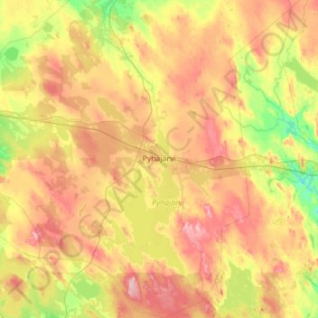
Naam: Topografische kaart Pyhäjärvi, hoogte, reliëf.
Gemiddelde hoogte: 147 m
Minimale hoogte: 94 m
Maximale hoogte: 222 m
Andere topografische kaarten
Klik op een kaart om zijn topografie, zijn hoogte en zijn reliëf te bekijken.
Aakonpuhto
Finland > North Ostrobothnia > Haapavesi
Aakonpuhto, Haapavesi, Siikalatva sub-region, North Ostrobothnia, Regional State Administrative Agency for Northern Finland, Mainland Finland, Finland
Gemiddelde hoogte: 120 m
Oulunsalo
Finland > North Ostrobothnia > Oulu
Oulunsalo, Oulu, Oulu sub-region, North Ostrobothnia, Regional State Administrative Agency for Northern Finland, Mainland Finland, 90460, Finland
Gemiddelde hoogte: 4 m
Raahe
Raahe, Raahe sub-region, North Ostrobothnia, Regional State Administrative Agency for Northern Finland, Mainland Finland, Finland
Gemiddelde hoogte: 30 m
Oulu
Oulu, Oulu sub-region, North Ostrobothnia, Regional State Administrative Agency for Northern Finland, Mainland Finland, Finland
Gemiddelde hoogte: 46 m
Kuusamo
Kuusamo, Koillismaa sub-region, North Ostrobothnia, Regional State Administrative Agency for Northern Finland, Mainland Finland, Finland
Gemiddelde hoogte: 266 m