
Topografische kaart Milford Sound / Piopiotahi
Interactieve kaart
Klik op de kaart om de hoogte weer te geven.
Over deze kaart
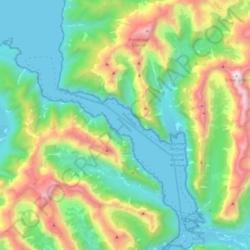
Naam: Topografische kaart Milford Sound / Piopiotahi, hoogte, reliëf.
Gemiddelde hoogte: 655 m
Minimale hoogte: -2 m
Maximale hoogte: 2.198 m
Der zwischen 455 m und knapp 3 km breite Fjord deckt eine Fläche von rund 25,3 km² ab und misst an seiner tiefsten Stelle eine Tiefe von 269 m, von wo aus sich die angrenzenden Berge teils sehr steil, bis zu zwischen 60 und 80 Grad ansteigend, mit dem Mitre Peak auf bis zu 1683 m Höhe erheben.
Andere topografische kaarten
Klik op een kaart om zijn topografie, zijn hoogte en zijn reliëf te bekijken.
Lake Te Au
Neuseeland > Southland > Southland District > Fiordland Community
Lake Te Au, Fiordland Community, Southland District, Southland, Neuseeland
Gemiddelde hoogte: 597 m
Te Anau
Neuseeland > Southland > Southland District > Fiordland Community
Te Anau, Fiordland Community, Southland District, Southland, 9600, Neuseeland
Gemiddelde hoogte: 249 m