
Topografische kaart Brasstown Bald
Interactieve kaart
Klik op de kaart om de hoogte weer te geven.
Over deze kaart
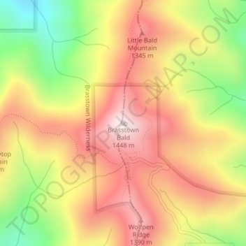
Naam: Topografische kaart Brasstown Bald, hoogte, reliëf.
Locatie: Brasstown Bald, Towns County, Georgia, United States (34.87431 -83.81110 34.87441 -83.81100)
Gemiddelde hoogte: 1.161 m
Minimale hoogte: 798 m
Maximale hoogte: 1.442 m
Andere topografische kaarten
Klik op een kaart om zijn topografie, zijn hoogte en zijn reliëf te bekijken.
Hiawassee
United States > Georgia > Towns County
Hiawassee, Towns County, Georgia, United States
Gemiddelde hoogte: 620 m
Macedonia
United States > Georgia > Towns County
Macedonia, Towns County, Georgia, 30546, United States
Gemiddelde hoogte: 637 m
Young Harris
United States > Georgia > Towns County
Young Harris, Towns County, Georgia, United States
Gemiddelde hoogte: 606 m
Friendship
United States > Georgia > Towns County > Friendship
Friendship, Towns County, Georgia, United States
Gemiddelde hoogte: 625 m