
Topografische kaart Apple Valley
Interactieve kaart
Klik op de kaart om de hoogte weer te geven.
Apple Valley
According to the United States Census Bureau, the city has a total area of 17.57 square miles (45.51 km2), of which 16.86 square miles (43.67 km2) is land and 0.71 square miles (1.84 km2) is water. The city's geography is rolling, with elevation from the lowest to the highest points in the city varying by a hundred feet or more. The downtown area and its adjacent residential district (which formed the original core of the city when it was incorporated) are in a shallow valley.
Over deze kaart
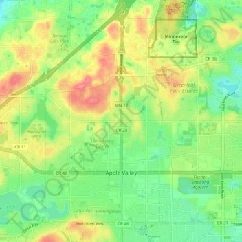
Naam: Topografische kaart Apple Valley, hoogte, reliëf.
Gemiddelde hoogte: 301 m
Minimale hoogte: 270 m
Maximale hoogte: 343 m