
Topografische kaart Aizawl
Interactieve kaart
Klik op de kaart om de hoogte weer te geven.
Over deze kaart
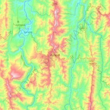
Naam: Topografische kaart Aizawl, hoogte, reliëf.
Locatie: Aizawl, Tlangnuam, Aizwal, Mizoram, 796190, India (23.58352 92.57829 23.90352 92.89829)
Gemiddelde hoogte: 556 m
Minimale hoogte: 61 m
Maximale hoogte: 1.509 m
Aizawl has a mild, sub-tropical climate due to its location and elevation. Under the Köppen climate classification, Aizawl features a humid subtropical climate (Cwa). In summer, temperatures are moderately warm, averaging around 20–30 °C (68–86 °F). In winter, daytime temperatures are cooler in comparison to the rest of the year, averaging around 11–21 °C (52–70 °F). Rainfall is mostly concentrated between April and October, with the heaviest rainfall occurring in May, July, August and September. The remainder of the year is notably drier.
Andere topografische kaarten
Klik op een kaart om zijn topografie, zijn hoogte en zijn reliëf te bekijken.