
Topografische kaart Annapolis
Interactieve kaart
Klik op de kaart om de hoogte weer te geven.
Annapolis
Annapolis lies within the humid subtropical climate zone (Köppen Cfa), with hot, humid summers, cool winters, and generous precipitation year-round. Low elevation and proximity to the Chesapeake Bay give the area more moderate spring and summertime temperatures and slightly less extreme winter lows than locations further inland, such as Washington, D.C.
Over deze kaart
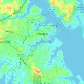
Naam: Topografische kaart Annapolis, hoogte, reliëf.
Gemiddelde hoogte: 8 m
Minimale hoogte: -5 m
Maximale hoogte: 34 m