
Topografische kaart Goliad County
Interactieve kaart
Klik op de kaart om de hoogte weer te geven.
Over deze kaart
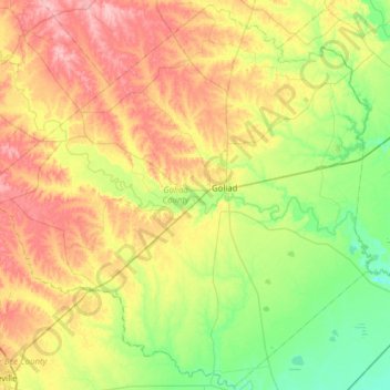
Naam: Topografische kaart Goliad County, hoogte, reliëf.
Locatie: Goliad County, Texas, United States (28.38868 -97.77839 28.92563 -97.15360)
Gemiddelde hoogte: 61 m
Minimale hoogte: 12 m
Maximale hoogte: 136 m
Andere topografische kaarten
Klik op een kaart om zijn topografie, zijn hoogte en zijn reliëf te bekijken.
Springfield Lake
United States > Texas > Limestone County
Springfield Lake, Limestone County, Texas, United States
Gemiddelde hoogte: 137 m
Angus
United States > Texas > Navarro County
Angus, Navarro County, Texas, United States
Gemiddelde hoogte: 119 m
Electra
United States > Texas > Wichita County
Electra, Wichita County, Texas, United States
Gemiddelde hoogte: 362 m
Alum
United States > Texas > Wilson County
Alum, Wilson County, Texas, United States
Gemiddelde hoogte: 152 m
Borger
United States > Texas > Hutchinson County
Borger, Hutchinson County, Texas, 79007, United States
Gemiddelde hoogte: 929 m
Mesquite
United States > Texas > Dallas County
Mesquite, Dallas County, Texas, United States
Gemiddelde hoogte: 142 m
San Antonio
United States > Texas > Bexar County
San Antonio, Bexar County, Texas, United States
Gemiddelde hoogte: 247 m
Lake Whitney State Park
United States > Texas > Hill County
Lake Whitney State Park, Hill County, Texas, United States
Gemiddelde hoogte: 165 m
McLean
United States > Texas > Gray County
McLean, Gray County, Texas, 79057, United States
Gemiddelde hoogte: 873 m
Midlothian
United States > Texas > Ellis County
Midlothian, Ellis County, Texas, 76065, United States
Gemiddelde hoogte: 212 m
Frisco
United States > Texas > Collin County
Frisco, Collin County, Texas, United States
Gemiddelde hoogte: 201 m
Canton
United States > Texas > Van Zandt County
Canton, Van Zandt County, Texas, 75103, United States
Gemiddelde hoogte: 159 m
South Lake
United States > Texas > Hill County
South Lake, Hill County, Texas, United States
Gemiddelde hoogte: 189 m
Allen
United States > Texas > Collin County
Allen, Collin County, Texas, United States
Gemiddelde hoogte: 200 m
Converse
United States > Texas > Bexar County
Converse, Bexar County, Texas, 78109, United States
Gemiddelde hoogte: 223 m
Duke
United States > Texas > Fort Bend County > Arcola
Duke, Arcola, Fort Bend County, Texas, 77545, United States
Gemiddelde hoogte: 20 m
Plano
United States > Texas > Collin County
Plano, Collin County, Texas, United States
Gemiddelde hoogte: 196 m
Soil Conservation Service Site 12 Dam
United States > Texas > Williamson County > Type
Soil Conservation Service Site 12 Dam, Type, Williamson County, Texas, United States
Gemiddelde hoogte: 173 m
El Paso
United States > Texas > El Paso County
El Paso, El Paso County, Texas, United States
Gemiddelde hoogte: 1.237 m
Elsa
United States > Texas > Hidalgo County
Elsa, Hidalgo County, Texas, 78543, United States
Gemiddelde hoogte: 22 m
Bayview
United States > Texas > Cameron County
Bayview, Cameron County, Texas, United States
Gemiddelde hoogte: 7 m
Willow Grove
United States > Texas > McLennan County
Willow Grove, McLennan County, Texas, 76702, United States
Gemiddelde hoogte: 169 m
Lubbock
United States > Texas > Lubbock County
Lubbock, Lubbock County, Texas, United States
Gemiddelde hoogte: 983 m
Moran
United States > Texas > Shackelford County
Moran, Shackelford County, Texas, United States
Gemiddelde hoogte: 411 m
Sun Valley
United States > Texas > Lamar County
Sun Valley, Lamar County, Texas, United States
Gemiddelde hoogte: 166 m
Cleveland
United States > Texas > Liberty County
Cleveland, Liberty County, Texas, 77327, United States
Gemiddelde hoogte: 47 m
Seymour
United States > Texas > Baylor County
Seymour, Baylor County, Texas, 76380, United States
Gemiddelde hoogte: 401 m
Crystal City
United States > Texas > Zavala County
Crystal City, Zavala County, Texas, 78839, United States
Gemiddelde hoogte: 174 m
Carrizo Springs
United States > Texas > Dimmit County
Carrizo Springs, Dimmit County, Texas, 78834, United States
Gemiddelde hoogte: 185 m
Horseshoe Bay
United States > Texas > Llano County
Horseshoe Bay, Llano County, Texas, 78657, United States
Gemiddelde hoogte: 290 m
Omen
United States > Texas > Smith County
Omen, Smith County, Texas, 75750, United States
Gemiddelde hoogte: 135 m
Signal Hill
United States > Texas > Williamson County
Signal Hill, Williamson County, Texas, United States
Gemiddelde hoogte: 291 m
Dublin
United States > Texas > Erath County
Dublin, Erath County, Texas, 76446, United States
Gemiddelde hoogte: 451 m
Mayhill
United States > Texas > Denton County > Denton
Mayhill, Denton, Denton County, Texas, 76208, United States
Gemiddelde hoogte: 183 m
Canturbury Trails Park
United States > Texas > Travis County > Austin
Canturbury Trails Park, Austin, Travis County, Texas, United States
Gemiddelde hoogte: 210 m
Carpenters Bluff
United States > Texas > Grayson County
Carpenters Bluff, Grayson County, Texas, United States
Gemiddelde hoogte: 165 m
Lake Cooper
United States > Texas > Archer County
Lake Cooper, Archer County, Texas, United States
Gemiddelde hoogte: 357 m