
Topografische kaart Baran
Interactieve kaart
Klik op de kaart om de hoogte weer te geven.
Baran
Baran is located at 25°06′N 76°31′E / 25.1°N 76.52°E / 25.1; 76.52. It has an average elevation of 262 metres (859 ft). It is surrounded by three Rivers Kalisindh, Parvati and Parban. The city is situated on the border of Rajasthan and Madhya Pradesh.
Over deze kaart
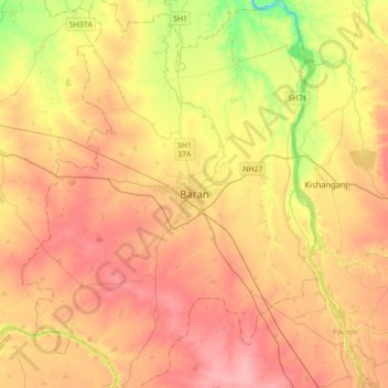
Naam: Topografische kaart Baran, hoogte, reliëf.
Locatie: Baran, Baran Tehsil, Baran District, Rajasthan, 325205, India (24.93819 76.35699 25.25819 76.67699)
Gemiddelde hoogte: 264 m
Minimale hoogte: 212 m
Maximale hoogte: 300 m