
Topografische kaart Kingston
Interactieve kaart
Klik op de kaart om de hoogte weer te geven.
Over deze kaart
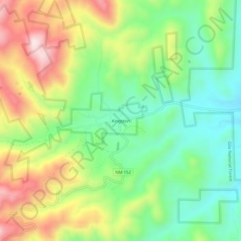
Naam: Topografische kaart Kingston, hoogte, reliëf.
Locatie: Kingston, Sierra County, New Mexico, United States (32.89702 -107.72614 32.93702 -107.68614)
Gemiddelde hoogte: 2.000 m
Minimale hoogte: 1.821 m
Maximale hoogte: 2.267 m
Andere topografische kaarten
Klik op een kaart om zijn topografie, zijn hoogte en zijn reliëf te bekijken.
Williamsburg
United States > New Mexico > Sierra County
Williamsburg, Sierra County, New Mexico, 87942, United States
Gemiddelde hoogte: 1.313 m
Mud Mountain
United States > New Mexico > Sierra County
Mud Mountain, Sierra County, New Mexico, 87942, United States
Gemiddelde hoogte: 1.506 m
Elephant Butte Lake
United States > New Mexico > Sierra County
Elephant Butte Lake, Sierra County, New Mexico, United States
Gemiddelde hoogte: 1.420 m
Truth or Consequences
United States > New Mexico > Sierra County > Truth or Consequences
Truth or Consequences, Sierra County, New Mexico, United States
Gemiddelde hoogte: 1.409 m
Elephant Butte
United States > New Mexico > Sierra County
Elephant Butte, Sierra County, New Mexico, 87935, United States
Gemiddelde hoogte: 1.359 m
Mount Baldy
United States > New Mexico > Sierra County
Mount Baldy, Sierra County, New Mexico, United States
Gemiddelde hoogte: 1.980 m