
Topografische kaart San Dieguito
Interactieve kaart
Klik op de kaart om de hoogte weer te geven.
Over deze kaart
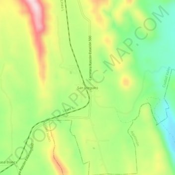
Naam: Topografische kaart San Dieguito, hoogte, reliëf.
Locatie: San Dieguito, Ciudad Valles, San Luis Potosí, 79243, México (21.98848 -99.24243 22.02848 -99.20243)
Gemiddelde hoogte: 333 m
Minimale hoogte: 193 m
Maximale hoogte: 514 m
Andere topografische kaarten
Klik op een kaart om zijn topografie, zijn hoogte en zijn reliëf te bekijken.
El Pujal
México > San Luis Potosí > Ciudad Valles > Ciudad Valles
El Pujal, Ciudad Valles, San Luis Potosí, 79293, México
Gemiddelde hoogte: 54 m
Rascón
México > San Luis Potosí > Ciudad Valles > Rascón
Rascón, Ciudad Valles, San Luis Potosí, 79241, México
Gemiddelde hoogte: 332 m
Ejido Montecillos
México > San Luis Potosí > Ciudad Valles > Ciudad Valles > Ejido Montecillos
Ejido Montecillos, Ciudad Valles, San Luis Potosí, 79000, México
Gemiddelde hoogte: 212 m
Ciudad Valles
México > San Luis Potosí > Ciudad Valles
Ciudad Valles, San Luis Potosí, 79000, México
Gemiddelde hoogte: 181 m