
Topografische kaart The District Council of Yankalilla
Interactieve kaart
Klik op de kaart om de hoogte weer te geven.
Over deze kaart
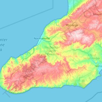
Naam: Topografische kaart The District Council of Yankalilla, hoogte, reliëf.
Gemiddelde hoogte: 119 m
Minimale hoogte: 0 m
Maximale hoogte: 440 m
Andere topografische kaarten
Klik op een kaart om zijn topografie, zijn hoogte en zijn reliëf te bekijken.
Normanville
Australia > South Australia > The District Council of Yankalilla
Normanville, The District Council of Yankalilla, South Australia, 5204, Australia
Gemiddelde hoogte: 64 m
Yankalilla
Australia > South Australia > The District Council of Yankalilla
Yankalilla, The District Council of Yankalilla, South Australia, 5203, Australia
Gemiddelde hoogte: 104 m
Tunkalilla
Australia > South Australia > The District Council of Yankalilla
Tunkalilla, The District Council of Yankalilla, South Australia, 5203, Australia
Gemiddelde hoogte: 181 m