
Topografische kaart Ringgold
Interactieve kaart
Klik op de kaart om de hoogte weer te geven.
Over deze kaart
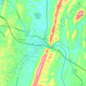
Naam: Topografische kaart Ringgold, hoogte, reliëf.
Locatie: Ringgold, Catoosa County, Georgia, United States of America (34.88789 -85.19659 34.93480 -85.08769)
Gemiddelde hoogte: 268 m
Minimale hoogte: 209 m
Maximale hoogte: 407 m
Ringgold is situated in the Valley and Ridge geologic province of the Appalachian Mountains, characterized by long north-northeasterly trending ridges separated by valleys. The topography was formed by the erosion of alternating layers of hard and soft sedimentary rock that were folded and faulted during the building of the Appalachians. Taylor Ridge runs through Ringgold; a gap in the ridge is located just east of the city center, with the part of the ridge running to the south called Taylors Ridge and to the north called White Oak Mountain. South Chickamauga Creek, a tributary of the Tennessee River, runs through Ringgold.