
Topografische kaart Mission Peak Regional Preserve
Interactieve kaart
Klik op de kaart om de hoogte weer te geven.
Over deze kaart
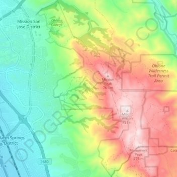
Naam: Topografische kaart Mission Peak Regional Preserve, hoogte, reliëf.
Gemiddelde hoogte: 322 m
Minimale hoogte: 3 m
Maximale hoogte: 805 m
Three trails climb the mountain's northern and western faces. The Hidden Valley Trail which draws the lion's share of visitors and the Peak Meadow Trail both ascend the western face from Stanford Avenue. They have an elevation change of 2,100 ft (640 m), with panoramic views of the Bay Area but are sun exposed with little shade. The Stanford Avenue entrance has water and restrooms. No food, water bottles or supplies are sold at the park. The Park District is directing visitors to the Mission Peak Trail which starts at Ohlone College. This has an elevation change of 2,100 ft (640 m), and is 10% longer than the Hidden Valley Trail. The Peak Trail (Ohlone College) entrance has restrooms and a water fountain.