
Topografische kaart Kildimo
Interactieve kaart
Klik op de kaart om de hoogte weer te geven.
Over deze kaart
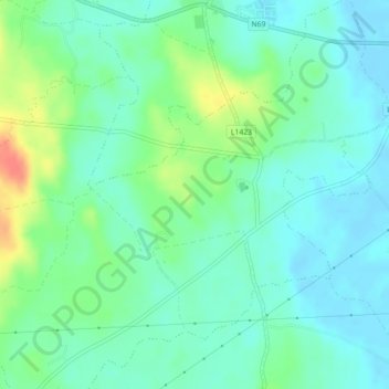
Naam: Topografische kaart Kildimo, hoogte, reliëf.
Gemiddelde hoogte: 10 m
Minimale hoogte: -2 m
Maximale hoogte: 36 m
Andere topografische kaarten
Klik op een kaart om zijn topografie, zijn hoogte en zijn reliëf te bekijken.
Adare
Ireland > County Limerick > The Municipal District of Adare — Rathkeale
Adare, The Municipal District of Adare — Rathkeale, County Limerick, Munster, Ireland
Gemiddelde hoogte: 12 m
Milltown Bridge
Ireland > County Limerick > The Municipal District of Adare — Rathkeale
Milltown Bridge, Dromard, The Municipal District of Adare — Rathkeale, County Limerick, Munster, V94 HF80, Ireland
Gemiddelde hoogte: 29 m
Rathmore
Ireland > County Limerick > The Municipal District of Adare — Rathkeale
Rathmore, The Municipal District of Adare — Rathkeale, County Limerick, Munster, Ireland
Gemiddelde hoogte: 56 m
Marlbrook
Ireland > County Limerick > The Municipal District of Adare — Rathkeale
Marlbrook, Kilpeacon, The Municipal District of Adare — Rathkeale, County Limerick, Munster, Ireland
Gemiddelde hoogte: 35 m