
Topografische kaart Nyúl
Interactieve kaart
Klik op de kaart om de hoogte weer te geven.
Over deze kaart
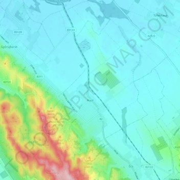
Naam: Topografische kaart Nyúl, hoogte, reliëf.
Gemiddelde hoogte: 151 m
Minimale hoogte: 113 m
Maximale hoogte: 316 m
Andere topografische kaarten
Klik op een kaart om zijn topografie, zijn hoogte en zijn reliëf te bekijken.
Pannonhalma
Hungría > Győr-Moson-Sopron vármegye
Pannonhalma, Pannonhalmi járás, Győr-Moson-Sopron vármegye, Transdanubio Occidental, Transdanubia, 9090, Hungría
Gemiddelde hoogte: 172 m
Ravazd
Hungría > Győr-Moson-Sopron vármegye
Ravazd, Pannonhalmi járás, Győr-Moson-Sopron vármegye, Transdanubio Occidental, Transdanubia, 9091, Hungría
Gemiddelde hoogte: 207 m
Lila-hegy
Hungría > Győr-Moson-Sopron vármegye > Győrújbarát
Lila-hegy, Győrújbarát, Győri járás, Győr-Moson-Sopron vármegye, Transdanubio Occidental, Transdanubia, 9082, Hungría
Gemiddelde hoogte: 217 m
Nyúlhegy
Hungría > Győr-Moson-Sopron vármegye > Nyúl
Nyúlhegy, Nyúl, Győri járás, Győr-Moson-Sopron vármegye, Transdanubio Occidental, Transdanubia, 9082, Hungría
Gemiddelde hoogte: 192 m
Győr
Hungría > Győr-Moson-Sopron vármegye
Győr, Győri járás, Győr-Moson-Sopron vármegye, Transdanubio Occidental, Transdanubia, Hungría
Gemiddelde hoogte: 120 m