
Topografische kaart Aniakchak National Monument
Interactieve kaart
Klik op de kaart om de hoogte weer te geven.
Aniakchak National Monument
The national monument is centered on the 6-mile (9.7 km) diameter crater of ancient Mount Aniakchak, which was destroyed and the resulting crater formed during a caldera collapse event about 3,700 years ago. The original mountain, about 7,000 feet (2,100 m) tall, collapsed into its magma chamber, leaving an approximate 3,300-foot (1,000 m) deep summit crater. (The elevation of the high point on the crater rim, Aniakchak Peak, is approximately 4,380 feet. The elevation of the low point of the caldera floor, at the mouth of Surprise Lake and the beginning of the Aniakchak River, is approximately 1,055 feet.) The monument and surrounding preserve include the volcanic feature, the wild Aniakchak River, the Bristol Bay coastal habitat, and portions of the coast of the Pacific Ocean.
Over deze kaart
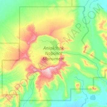
Naam: Topografische kaart Aniakchak National Monument, hoogte, reliëf.
Gemiddelde hoogte: 376 m
Minimale hoogte: 31 m
Maximale hoogte: 1.321 m
Andere topografische kaarten
Klik op een kaart om zijn topografie, zijn hoogte en zijn reliëf te bekijken.