
Topografische kaart Manorhamilton
Interactieve kaart
Klik op de kaart om de hoogte weer te geven.
Over deze kaart
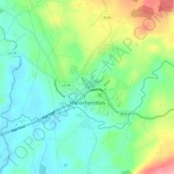
Naam: Topografische kaart Manorhamilton, hoogte, reliëf.
Gemiddelde hoogte: 70 m
Minimale hoogte: 35 m
Maximale hoogte: 139 m
Andere topografische kaarten
Klik op een kaart om zijn topografie, zijn hoogte en zijn reliëf te bekijken.
Leckaun
Leckaun, Drumkeeran ED, Manorhamilton Municipal District, County Leitrim, Connacht, Ireland
Gemiddelde hoogte: 220 m
Glenfarne
Glenfarne, Glenfarn ED, Manorhamilton Municipal District, County Leitrim, Connacht, Ireland
Gemiddelde hoogte: 90 m
Glenade
Glenade, Aghalateeve ED, Manorhamilton Municipal District, County Leitrim, Connacht, Ireland
Gemiddelde hoogte: 163 m
Knockacullion
Knockacullion, Ballinamore Municipal District, County Leitrim, Connacht, Ireland
Gemiddelde hoogte: 443 m
Aghacashel
Aghacashel, Aghacashel ED, Ballinamore Municipal District, County Leitrim, Connacht, Ireland
Gemiddelde hoogte: 145 m
Lavagh
Lavagh, Drumsna ED, Carrick-on-Shannon Municipal District, County Leitrim, Connacht, Ireland
Gemiddelde hoogte: 56 m
Lough Nacarriga
Lough Nacarriga, Castlefore ED, Ballinamore Municipal District, County Leitrim, Connacht, Ireland
Gemiddelde hoogte: 73 m
Nure
Nure, Lurganboy ED, Manorhamilton Municipal District, County Leitrim, Connacht, Ireland
Gemiddelde hoogte: 113 m
Ballyglass
Ballyglass, Lurganboy ED, Manorhamilton Municipal District, County Leitrim, Connacht, Ireland
Gemiddelde hoogte: 92 m
Morerah
Morerah, Lurganboy ED, Manorhamilton Municipal District, County Leitrim, Connacht, Ireland
Gemiddelde hoogte: 199 m
Fawn
Fawn, Drumahaire ED, Manorhamilton Municipal District, County Leitrim, Connacht, Ireland
Gemiddelde hoogte: 56 m
Lisgavneen
Lisgavneen, Drumkeeran ED, Manorhamilton Municipal District, County Leitrim, Connacht, Ireland
Gemiddelde hoogte: 207 m
Carrick-on-Shannon Municipal District
Carrick-on-Shannon Municipal District, County Leitrim, Connacht, Ireland
Gemiddelde hoogte: 63 m
Ross More
Ross More, Mahanagh ED, Manorhamilton Municipal District, County Leitrim, Connacht, Ireland
Gemiddelde hoogte: 60 m
Carrigallen
Carrigallen, County Leitrim, Connacht, Ireland
Gemiddelde hoogte: 88 m
Killooman
Killooman, Killarga ED, Manorhamilton Municipal District, County Leitrim, Connacht, Ireland
Gemiddelde hoogte: 284 m
Tawley
Tawley, Tullaghan ED, Manorhamilton Municipal District, County Leitrim, Connacht, Ireland
Gemiddelde hoogte: 39 m
Ross Lough
Ross Lough, Manorhamilton ED, Manorhamilton Municipal District, County Leitrim, Connacht, Ireland
Gemiddelde hoogte: 69 m
Carrick-on-Shannon
Ireland > County Leitrim > Carrick-on-Shannon
Carrick-on-Shannon, Carrick-on-Shannon Municipal District, County Leitrim, Connacht, N41 N9W4, Ireland
Gemiddelde hoogte: 55 m
Furnace or Bleankillew
Furnace or Bleankillew, Dromod, Carrick-on-Shannon Municipal District, County Leitrim, Connacht, Ireland
Gemiddelde hoogte: 47 m
Stradermot
Stradermot, Ballinamore ED, Ballinamore Municipal District, County Leitrim, Connacht, Ireland
Gemiddelde hoogte: 71 m
Derryduff
Derryduff, Tullaghan ED, Manorhamilton Municipal District, County Leitrim, Connacht, Ireland
Gemiddelde hoogte: 26 m
Manorhamilton Municipal District
Manorhamilton Municipal District, County Leitrim, Connacht, Ireland
Gemiddelde hoogte: 156 m
Keeloges
Keeloges, Manorhamilton Municipal District, County Leitrim, Connacht, Ireland
Gemiddelde hoogte: 250 m
Ballinamore Municipal District
Ballinamore Municipal District, County Leitrim, Connacht, Ireland
Gemiddelde hoogte: 109 m
Cloone
Cloone, Ballinamore Municipal District, County Leitrim, Connacht, Ireland
Gemiddelde hoogte: 65 m
Aghaboneill
Aghaboneill, Rowan ED, Ballinamore Municipal District, County Leitrim, Connacht, Ireland
Gemiddelde hoogte: 78 m
Drumshanbo
Ireland > County Leitrim > Drumshanbo
Drumshanbo, Ballinamore Municipal District, County Leitrim, Connacht, Ireland
Gemiddelde hoogte: 84 m
Dromod
Dromod, Carrick-on-Shannon Municipal District, County Leitrim, Connacht, Ireland
Gemiddelde hoogte: 49 m
Saint Patrick's Island
Saint Patrick's Island, Glenfarn ED, Manorhamilton Municipal District, County Leitrim, Connacht, Ireland
Gemiddelde hoogte: 69 m