
Topografische kaart Gaithersburg
Interactieve kaart
Klik op de kaart om de hoogte weer te geven.
Over deze kaart
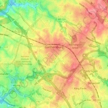
Naam: Topografische kaart Gaithersburg, hoogte, reliëf.
Locatie: Gaithersburg, Montgomery County, Maryland, United States (39.10275 -77.25827 39.16831 -77.17118)
Gemiddelde hoogte: 137 m
Minimale hoogte: 93 m
Maximale hoogte: 171 m
Andere topografische kaarten
Klik op een kaart om zijn topografie, zijn hoogte en zijn reliëf te bekijken.
Forest Glen
United States > Maryland > Montgomery County > Forest Glen > McKenney Hills
Forest Glen, McKenney Hills, Forest Glen, Montgomery County, Maryland, United States
Gemiddelde hoogte: 105 m
Forest Glen
United States > Maryland > Montgomery County
Forest Glen, Montgomery County, Maryland, 20895, United States
Gemiddelde hoogte: 96 m
Rockville
United States > Maryland > Montgomery County
Rockville, Montgomery County, Maryland, United States
Gemiddelde hoogte: 122 m
Germantown
United States > Maryland > Montgomery County > Germantown
Germantown, Montgomery County, Maryland, United States
Gemiddelde hoogte: 130 m
Redland
United States > Maryland > Montgomery County
Redland, Montgomery County, Maryland, 20855, United States
Gemiddelde hoogte: 139 m
Damascus
United States > Maryland > Montgomery County > Damascus
Damascus, Montgomery County, Maryland, 20872, United States
Gemiddelde hoogte: 195 m