
Topografische kaart Walkerton
Interactieve kaart
Klik op de kaart om de hoogte weer te geven.
Over deze kaart
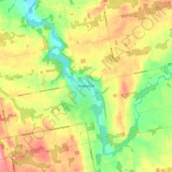
Naam: Topografische kaart Walkerton, hoogte, reliëf.
Locatie: Walkerton, Brockton, Bruce County, Ontario, N0G 2V0, Canada (44.09319 -81.18859 44.17319 -81.10859)
Gemiddelde hoogte: 286 m
Minimale hoogte: 237 m
Maximale hoogte: 334 m
Andere topografische kaarten
Klik op een kaart om zijn topografie, zijn hoogte en zijn reliëf te bekijken.
Greenock
Canada > Ontario > Bruce County > Brockton
Greenock, Brockton, Bruce County, Southwestern Ontario, Ontario, N0G 1K0, Canada
Gemiddelde hoogte: 272 m