
Topografische kaart Biljurashi
Interactieve kaart
Klik op de kaart om de hoogte weer te geven.
Over deze kaart
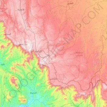
Naam: Topografische kaart Biljurashi, hoogte, reliëf.
Locatie: Biljurashi, Al-Bahah Province, Saudi Arabia (19.69809 41.50283 20.29958 41.97897)
Gemiddelde hoogte: 1.528 m
Minimale hoogte: 268 m
Maximale hoogte: 2.563 m
Baljurashi (Arabic: بَـلْـجُـرَشِي) or Biljurashi (Arabic: بِـلْـجُـرَشِي) is a city in Al Bahah Region, south-western Saudi Arabia. It is located at around 19°51′40″N 41°33′40″E / 19.8612090°N 41.5609769°E / 19.8612090; 41.5609769 in the elevation of cca 2,000 metres (6,600 feet). It was the capital of the region which includes the tribes of Ghamid and Zahran. It is a medium-sized city in Al Bahah Region. The temperature usually varies between 2 °C (36 °F) in winter and 30 °C (86 °F) in summer. The best time for a visit is from mid-August till the end of September. Most of the native people of Baljurashi live outside it; however, a great number of them spend their summer vacations in the city, which explains the massive increase in population number during summer.
Andere topografische kaarten
Klik op een kaart om zijn topografie, zijn hoogte en zijn reliëf te bekijken.
القعر
Saudi Arabia > Al-Bahah Province
القعر, Al Mukhwah, Al-Bahah Province, Saudi Arabia
Gemiddelde hoogte: 392 m
Al Aqiq
Saudi Arabia > Al-Bahah Province
Al Aqiq, Al-Bahah Province, Saudi Arabia
Gemiddelde hoogte: 1.498 m
Al `Aqiq
Saudi Arabia > Al-Bahah Province
Al `Aqiq, Al Aqiq, Al-Bahah Province, Saudi Arabia
Gemiddelde hoogte: 1.583 m
Al Bahah
Saudi Arabia > Al-Bahah Province
Al Bahah, Al-Bahah Province, Saudi Arabia
Gemiddelde hoogte: 1.854 m
Al Bahah
Saudi Arabia > Al-Bahah Province
Al Bahah, Al-Bahah Province, Saudi Arabia
Gemiddelde hoogte: 1.744 m