
Topografische kaart Glenridding Dodd
Interactieve kaart
Klik op de kaart om de hoogte weer te geven.
Over deze kaart
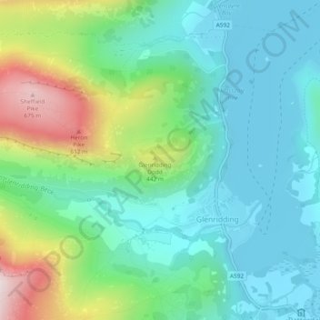
Naam: Topografische kaart Glenridding Dodd, hoogte, reliëf.
Gemiddelde hoogte: 293 m
Minimale hoogte: 143 m
Maximale hoogte: 695 m
Glenridding Dodd (the rounded hill above Glenridding) is a small fell in the English Lake District, at the end of a ridge descending from the Helvellyn range in the Eastern Fells. It stands above the village of Glenridding and on the western shore of Ullswater. Although small and not of great elevation, its top is a fine viewpoint for Ullswater and for the fells clustered round the valleys above Patterdale.
Andere topografische kaarten
Klik op een kaart om zijn topografie, zijn hoogte en zijn reliëf te bekijken.
The Tongue
United Kingdom > England > Eden
The Tongue, Eden, Cumbria, North West England, England, CA11 0XH, United Kingdom
Gemiddelde hoogte: 441 m
Eden
United Kingdom > England > Eden
Eden, Cumbria, North West England, England, United Kingdom
Gemiddelde hoogte: 318 m
Souther Fell
United Kingdom > England > Eden
Souther Fell, Eden, Cumbria, North West England, England, CA11 0XR, United Kingdom
Gemiddelde hoogte: 349 m
Cross Fell
United Kingdom > England > Eden
Cross Fell, Eden, Cumbria, North West England, England, United Kingdom
Gemiddelde hoogte: 753 m