
Topografische kaart Lee's Summit
Interactieve kaart
Klik op de kaart om de hoogte weer te geven.
Lee's Summit
When the surveyors for the Missouri Pacific Railroad came through, the local people and the railroad wanted to name the town in Dr. Lea's honor. He had a farm on the highest point and near the path of the tracks, and his murder had taken place near the site of the proposed depot. So they chose the name of "Lea's Summit", the "summit" portion to reflect its highest elevation on the Missouri Pacific Railroad between St. Louis and Kansas City. But they misspelled the name "Lees Summit" (with two "e's"; "Lee" instead of "Lea"; and leaving out the apostrophe) on a boxcar that was serving as a station and donated by the Missouri Pacific, then a sign next to the tracks, and finally in the printed time schedule for the railroad. Legend states that the name was spelled wrong on the side of the Missouri Pacific depot and has remained Lee's Summit ever since.
Over deze kaart
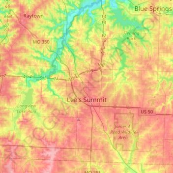
Naam: Topografische kaart Lee's Summit, hoogte, reliëf.
Locatie: Lee's Summit, Jackson County, Missouri, United States (38.82440 -94.47168 39.02672 -94.29365)
Gemiddelde hoogte: 291 m
Minimale hoogte: 233 m
Maximale hoogte: 338 m
Andere topografische kaarten
Klik op een kaart om zijn topografie, zijn hoogte en zijn reliëf te bekijken.
Richard L. Berkley Riverfront Park
United States > Missouri > Jackson County > Kansas City
Gemiddelde hoogte: 242 m
Downtown Kansas City
United States > Missouri > Jackson County > Downtown Kansas City
Gemiddelde hoogte: 271 m
Lee's Summit
United States > Missouri > Jackson County > Lee's Summit
When the surveyors for the Missouri Pacific Railroad came through, the local people and the railroad wanted to name the town in Dr. Lea's honor. He had a farm on the highest point and near the path of the tracks, and his murder had taken place near the site of the proposed depot. So they chose the name of…
Gemiddelde hoogte: 288 m