
Topografische kaart Town of Manlius
Interactieve kaart
Klik op de kaart om de hoogte weer te geven.
Over deze kaart
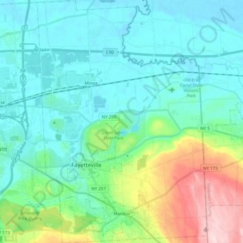
Naam: Topografische kaart Town of Manlius, hoogte, reliëf.
Locatie: Town of Manlius, Onondaga County, New York, United States (42.98525 -76.04249 43.12305 -75.91045)
Gemiddelde hoogte: 179 m
Minimale hoogte: 115 m
Maximale hoogte: 415 m
Andere topografische kaarten
Klik op een kaart om zijn topografie, zijn hoogte en zijn reliëf te bekijken.
Town of Cicero
United States > New York > Onondaga County
Town of Cicero, Onondaga County, New York, United States
Gemiddelde hoogte: 120 m
City of Syracuse
United States > New York > Onondaga County
City of Syracuse, Onondaga County, New York, United States
Gemiddelde hoogte: 172 m
Hiawatha Lake
United States > New York > Onondaga County > City of Syracuse
Hiawatha Lake, Strathmore, City of Syracuse, Onondaga County, New York, United States
Gemiddelde hoogte: 151 m
Town of Clay
United States > New York > Onondaga County
Town of Clay, Onondaga County, New York, United States
Gemiddelde hoogte: 120 m
Camillus
United States > New York > Onondaga County > Camillus
Camillus, Onondaga County, New York, United States
Gemiddelde hoogte: 177 m
Pompey
United States > New York > Onondaga County > Town of Pompey > Pompey
Pompey, Town of Pompey, Onondaga County, New York, 13138, United States
Gemiddelde hoogte: 450 m
Apulia
United States > New York > Onondaga County > Town of Fabius > Apulia
Apulia, Town of Fabius, Onondaga County, New York, 13020, United States
Gemiddelde hoogte: 409 m