
Topografische kaart Walnut Cove
Interactieve kaart
Klik op de kaart om de hoogte weer te geven.
Over deze kaart
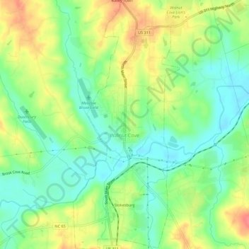
Naam: Topografische kaart Walnut Cove, hoogte, reliëf.
Locatie: Walnut Cove, Stokes County, North Carolina, United States (36.27498 -80.15314 36.31956 -80.12946)
Gemiddelde hoogte: 206 m
Minimale hoogte: 179 m
Maximale hoogte: 243 m
Andere topografische kaarten
Klik op een kaart om zijn topografie, zijn hoogte en zijn reliëf te bekijken.
Hanging Rock
United States > North Carolina > Stokes County
Hanging Rock, Stokes County, North Carolina, United States
Gemiddelde hoogte: 461 m
Dalton
United States > North Carolina > Stokes County
Dalton, Stokes County, North Carolina, United States
Gemiddelde hoogte: 287 m
Danbury
United States > North Carolina > Stokes County > Danbury
Danbury, Stokes County, North Carolina, United States
Gemiddelde hoogte: 264 m
King
United States > North Carolina > Stokes County > King
King, Stokes County, North Carolina, United States
Gemiddelde hoogte: 308 m
Shelton Store
United States > North Carolina > Stokes County > Shelton Store
Shelton Store, Stokes County, North Carolina, 27046, United States
Gemiddelde hoogte: 323 m