
Topografische kaart Butler County
Interactieve kaart
Klik op de kaart om de hoogte weer te geven.
Over deze kaart
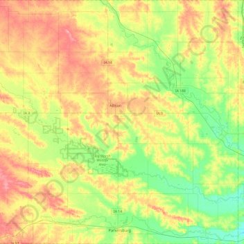
Naam: Topografische kaart Butler County, hoogte, reliëf.
Locatie: Butler County, Iowa, United States (42.55579 -93.02700 42.90754 -92.55422)
Gemiddelde hoogte: 303 m
Minimale hoogte: 264 m
Maximale hoogte: 350 m
Andere topografische kaarten
Klik op een kaart om zijn topografie, zijn hoogte en zijn reliëf te bekijken.
Ruthven
United States > Iowa > Palo Alto County
Ruthven, Palo Alto County, Iowa, United States
Gemiddelde hoogte: 431 m
Ozark
United States > Iowa > Jackson County
Ozark, Jackson County, Iowa, United States
Gemiddelde hoogte: 266 m
Western
United States > Iowa > Linn County
Western, Linn County, Iowa, United States
Gemiddelde hoogte: 250 m
Sulphur Springs
United States > Iowa > Buena Vista County
Sulphur Springs, Buena Vista County, Iowa, United States
Gemiddelde hoogte: 400 m
Woodbine
United States > Iowa > Harrison County
Woodbine, Harrison County, Iowa, United States
Gemiddelde hoogte: 328 m
Menlo
United States > Iowa > Guthrie County
Menlo, Guthrie County, Iowa, 50164, United States
Gemiddelde hoogte: 378 m
Parnell
United States > Iowa > Iowa County
Parnell, Iowa County, Iowa, United States
Gemiddelde hoogte: 253 m
Rock Valley
United States > Iowa > Sioux County
Rock Valley, Sioux County, Iowa, 51247, United States
Gemiddelde hoogte: 394 m
Ashton
United States > Iowa > Osceola County
Ashton, Osceola County, Iowa, United States
Gemiddelde hoogte: 448 m
Lakeside
United States > Iowa > Buena Vista County
Lakeside, Buena Vista County, Iowa, United States
Gemiddelde hoogte: 427 m
West Des Moines
United States > Iowa > Polk County
West Des Moines, Polk County, Iowa, United States
Gemiddelde hoogte: 280 m
Farley
United States > Iowa > Dubuque County
Farley, Dubuque County, Iowa, 52046, United States
Gemiddelde hoogte: 335 m
Bedford
United States > Iowa > Taylor County
Bedford, Taylor County, Iowa, 50833, United States
Gemiddelde hoogte: 354 m
Cloverdale
United States > Iowa > Osceola County
Cloverdale, Osceola County, Iowa, United States
Gemiddelde hoogte: 467 m
Iowa City
United States > Iowa > Johnson County
Iowa City, Johnson County, Iowa, United States
Gemiddelde hoogte: 216 m
Winthrop
United States > Iowa > Buchanan County
Winthrop, Buchanan County, Iowa, United States
Gemiddelde hoogte: 315 m
Kinross
United States > Iowa > Keokuk County
Kinross, Keokuk County, Iowa, United States
Gemiddelde hoogte: 243 m
Beaconsfield
United States > Iowa > Ringgold County
Beaconsfield, Ringgold County, Iowa, United States
Gemiddelde hoogte: 364 m
Denison
United States > Iowa > Crawford County
Denison, Crawford County, Iowa, 51442, United States
Gemiddelde hoogte: 386 m
Bertram
United States > Iowa > Linn County
Bertram, Linn County, Iowa, United States
Gemiddelde hoogte: 232 m
Somers
United States > Iowa > Calhoun County
Somers, Calhoun County, Iowa, United States
Gemiddelde hoogte: 352 m
Harvey
United States > Iowa > Marion County
Harvey, Marion County, Iowa, United States
Gemiddelde hoogte: 223 m
Ossian
United States > Iowa > Winneshiek County
Ossian, Winneshiek County, Iowa, United States
Gemiddelde hoogte: 375 m
Point Ann
United States > Iowa > Clayton County > McGregor
Point Ann, McGregor, Clayton County, Iowa, 52158, United States
Gemiddelde hoogte: 228 m
Denver
United States > Iowa > Bremer County
Denver, Bremer County, Iowa, 50622, United States
Gemiddelde hoogte: 298 m
Mount Pleasant
United States > Iowa > Henry County
Mount Pleasant, Henry County, Iowa, 52641, United States
Gemiddelde hoogte: 215 m
McClelland
United States > Iowa > Pottawattamie County
McClelland, Pottawattamie County, Iowa, United States
Gemiddelde hoogte: 369 m
Spring Hill
United States > Iowa > Warren County
Spring Hill, Warren County, Iowa, United States
Gemiddelde hoogte: 263 m
Henderson
United States > Iowa > Mills County > Henderson
Henderson, Mills County, Iowa, United States
Gemiddelde hoogte: 326 m
Carlisle
United States > Iowa > Warren County > Carlisle
Carlisle, Warren County, Iowa, 50047, United States
Gemiddelde hoogte: 244 m
Palmyra
United States > Iowa > Warren County
Palmyra, Warren County, Iowa, 50118, United States
Gemiddelde hoogte: 268 m
Morley
United States > Iowa > Jones County > Morley > Morley
Morley, Jones County, Iowa, 52312, United States
Gemiddelde hoogte: 253 m
Northwood
United States > Iowa > Worth County > Northwood
Northwood, Worth County, Iowa, United States
Gemiddelde hoogte: 373 m
Miles
United States > Iowa > Jackson County
Miles, Jackson County, Iowa, United States
Gemiddelde hoogte: 248 m
Hills
United States > Iowa > Johnson County > Hills > Hills
Hills, Johnson County, Iowa, 52235, United States
Gemiddelde hoogte: 196 m
Beaconsfield
United States > Iowa > Ringgold County > Beaconsfield > Beaconsfield
Beaconsfield, Ringgold County, Iowa, 50084, United States
Gemiddelde hoogte: 361 m
Burlington
United States > Iowa > Des Moines County > Burlington
Burlington, Des Moines County, Iowa, 52601, United States
Gemiddelde hoogte: 183 m
Mapleton
United States > Iowa > Monona County
Mapleton, Monona County, Iowa, United States
Gemiddelde hoogte: 351 m
Hiawatha
United States > Iowa > Linn County > Hiawatha
Hiawatha, Linn County, Iowa, 52233, United States
Gemiddelde hoogte: 256 m
Avoca
United States > Iowa > Pottawattamie County
Avoca, Pottawattamie County, Iowa, 51521, United States
Gemiddelde hoogte: 353 m
Spencer
United States > Iowa > Clay County > Spencer
Spencer, Clay County, Iowa, 51301, United States
Gemiddelde hoogte: 406 m
Stanhope
United States > Iowa > Hamilton County
Stanhope, Hamilton County, Iowa, United States
Gemiddelde hoogte: 337 m
Clive
United States > Iowa > Polk County
Clive, Polk County, Iowa, 50325, United States
Gemiddelde hoogte: 287 m
Solomon
United States > Iowa > Mills County > Solomon
Solomon, Mills County, Iowa, 51645, United States
Gemiddelde hoogte: 343 m