
Topografische kaart Armadale
Interactieve kaart
Klik op de kaart om de hoogte weer te geven.
Over deze kaart
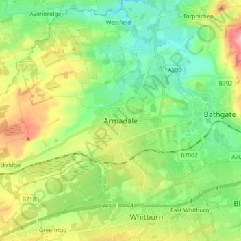
Naam: Topografische kaart Armadale, hoogte, reliëf.
Locatie: Armadale, West Lothian, Scotland, EH48 3QB, United Kingdom (55.85877 -3.74020 55.93877 -3.66020)
Gemiddelde hoogte: 166 m
Minimale hoogte: 101 m
Maximale hoogte: 293 m
Aside from the presence of the old castle, Armadale was little more than a rural farm community for most of its history, as part of a larger rural estate named Barbauchlaw (a corruption of 'Boar Baughlee'). However, this situation changed with the coming of the new turnpike road between Edinburgh and Glasgow in 1786, with Armadale having a location at a main highway junction on both the new regular east/west stagecoach route and also the old main north/south cattle droving route. This led to the establishment of a small village, including the establishment of a coaching inn (opening in 1797) and toll house. The toll house at Armadale was built where the new road intersected with an existing road in the east of the estate. The estate comprising the lands of Barbauchlaw was sold to Sir William Honeyman in 1790 and upon his elevation to the bench in 1797 he took the title of Lord Armadale (from his mother's estate in Sutherland) and this name was then applied to the township.
Andere topografische kaarten
Klik op een kaart om zijn topografie, zijn hoogte en zijn reliëf te bekijken.
Livingston
United Kingdom > Scotland > West Lothian
Livingston, West Lothian, Scotland, EH54 6HS, United Kingdom
Gemiddelde hoogte: 158 m
Bathgate
United Kingdom > Scotland > West Lothian
Bathgate, West Lothian, Scotland, EH48 1PA, United Kingdom
Gemiddelde hoogte: 167 m
Blackridge
United Kingdom > Scotland > West Lothian
Blackridge, West Lothian, Scotland, EH48 3SD, United Kingdom
Gemiddelde hoogte: 201 m
Breich
United Kingdom > Scotland > West Lothian
Breich, West Lothian, Scotland, EH55 8JN, United Kingdom
Gemiddelde hoogte: 236 m
Kirknewton
United Kingdom > Scotland > West Lothian
Kirknewton, West Lothian, Scotland, EH27 8AH, United Kingdom
Gemiddelde hoogte: 157 m
Polbeth
United Kingdom > Scotland > West Lothian
Polbeth, West Lothian, Scotland, EH55 8SP, United Kingdom
Gemiddelde hoogte: 166 m
Torphichen
United Kingdom > Scotland > West Lothian
Torphichen, West Lothian, Scotland, EH48 4LY, United Kingdom
Gemiddelde hoogte: 162 m
Abercorn
United Kingdom > Scotland > West Lothian
Abercorn, West Lothian, Scotland, EH30 9SL, United Kingdom
Gemiddelde hoogte: 36 m
Linlithgow
United Kingdom > Scotland > West Lothian
Linlithgow, West Lothian, Scotland, EH49 7EY, United Kingdom
Gemiddelde hoogte: 95 m
Cobbinshaw
United Kingdom > Scotland > West Lothian
Cobbinshaw, West Lothian, Scotland, EH55 8LQ, United Kingdom
Gemiddelde hoogte: 274 m
Deans
United Kingdom > Scotland > West Lothian
Deans, West Lothian, Scotland, United Kingdom
Gemiddelde hoogte: 164 m
Faucheldean
United Kingdom > Scotland > West Lothian > Broxburn
Faucheldean, Broxburn, West Lothian, Scotland, EH52 6PS, United Kingdom
Gemiddelde hoogte: 87 m
Campbridge Pond
United Kingdom > Scotland > West Lothian > Livingston
Campbridge Pond, Bellsquarry, Livingston, West Lothian, Scotland, United Kingdom
Gemiddelde hoogte: 179 m
Winchburgh
United Kingdom > Scotland > West Lothian
Winchburgh, West Lothian, Scotland, EH52 6FD, United Kingdom
Gemiddelde hoogte: 84 m
Fauldhouse
United Kingdom > Scotland > West Lothian
Fauldhouse, West Lothian, Scotland, EH47 9LP, United Kingdom
Gemiddelde hoogte: 245 m
Ballencrieff Reservoir
United Kingdom > Scotland > West Lothian > Bathgate
Ballencrieff Reservoir, Bathgate, West Lothian, Scotland, United Kingdom
Gemiddelde hoogte: 204 m
Blackburn
United Kingdom > Scotland > West Lothian
Blackburn, West Lothian, Scotland, EH47 7QN, United Kingdom
Gemiddelde hoogte: 172 m
Longridge
United Kingdom > Scotland > West Lothian > Longridge
Longridge, West Lothian, Scotland, EH47 8NZ, United Kingdom
Gemiddelde hoogte: 217 m
Addiewell
United Kingdom > Scotland > West Lothian
Addiewell, West Lothian, Scotland, EH55 8HN, United Kingdom
Gemiddelde hoogte: 196 m
East Calder
United Kingdom > Scotland > West Lothian
East Calder, West Lothian, Scotland, EH53 0EL, United Kingdom
Gemiddelde hoogte: 140 m
Whitburn
United Kingdom > Scotland > West Lothian
Whitburn, West Lothian, Scotland, EH47 0QA, United Kingdom
Gemiddelde hoogte: 191 m
West Calder
United Kingdom > Scotland > West Lothian
West Calder, West Lothian, Scotland, EH55 8BY, United Kingdom
Gemiddelde hoogte: 179 m
Uphall
United Kingdom > Scotland > West Lothian
Uphall, West Lothian, Scotland, EH52 5JQ, United Kingdom
Gemiddelde hoogte: 121 m
Broxburn
United Kingdom > Scotland > West Lothian
Broxburn, West Lothian, Scotland, EH52 5AG, United Kingdom
Gemiddelde hoogte: 97 m
Uphall Station
United Kingdom > Scotland > West Lothian
Uphall Station, West Lothian, Scotland, EH54 5PL, United Kingdom
Gemiddelde hoogte: 121 m
Dechmont
United Kingdom > Scotland > West Lothian
Dechmont, West Lothian, Scotland, United Kingdom
Gemiddelde hoogte: 155 m
Harperrig Reservoir
United Kingdom > Scotland > West Lothian
Harperrig Reservoir, West Lothian, Scotland, United Kingdom
Gemiddelde hoogte: 295 m
Ecclesmachan
United Kingdom > Scotland > West Lothian
Ecclesmachan, West Lothian, Scotland, EH52 6NG, United Kingdom
Gemiddelde hoogte: 118 m
Polbeth
United Kingdom > Scotland > West Lothian
Polbeth, West Lothian, Scotland, EH55 8TT, United Kingdom
Gemiddelde hoogte: 163 m