Geolokaliseren
👉 Easily get elevation data in JSON, GeoTIFF and KML formats using Elevation API
Bedankt voor het steunen van deze site ❤️
Doe een donatie

Rust jezelf uit voor je volgende avontuur:

Als Amazon-partner verdient deze site een commissie op in aanmerking komende aankopen, zonder extra kosten voor jou.

Topografische kaart Plymouth

Klik op de kaart om de hoogte weer te geven.

Plymouth

The River Plym, which flows off Dartmoor to the north-east, forms a smaller estuary to the east of the city called Cattewater. Plymouth Sound is protected from the sea by the Plymouth Breakwater, in use since 1814. In the Sound is Drake's Island which is seen from Plymouth Hoe, a flat public area on top of limestone cliffs. The Unitary Authority of Plymouth is 79.83 square kilometres (30.82 sq mi). The topography rises from sea level to a height, at Roborough, of about 509 feet (155 m) above Ordnance Datum (AOD).

Over deze kaart

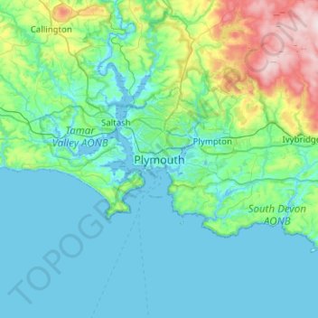
Naam: Topografische kaart Plymouth, hoogte, reliëf.

Locatie: Plymouth, Devon, South West England, England, PL1 1HH, United Kingdom (50.21127 -4.30257 50.53127 -3.98257)

Gemiddelde hoogte: 81 m

Minimale hoogte: -3 m

Maximale hoogte: 512 m

Rust jezelf uit voor je volgende avontuur:

💤Zelfopblaasbare Slaapmatten - Comfortabel slapen op elke ondergrond
📏Hoogtemeters - Apparaten om hoogte en stijging te meten
🗺️Wereldkaarten - Overzichtskaarten voor planning en inspiratie
🏞️Nationaal Park Gidsen - Gidsen voor natuurparken in Europa
📚Topografie Boeken - Boeken over landschap en reliëf

Als Amazon-partner verdient deze site een commissie op in aanmerking komende aankopen, zonder extra kosten voor jou.