
Topografische kaart Red Lodge
Interactieve kaart
Klik op de kaart om de hoogte weer te geven.
Over deze kaart
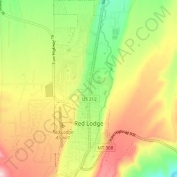
Naam: Topografische kaart Red Lodge, hoogte, reliëf.
Locatie: Red Lodge, Carbon County, Montana, 59068, United States (45.17150 -109.26051 45.21889 -109.23767)
Gemiddelde hoogte: 1.720 m
Minimale hoogte: 1.595 m
Maximale hoogte: 1.850 m
Red Lodge experiences a continental climate (Köppen Dfb) with cold, somewhat dry winters and warm, wetter summers. Summers are cooler than in areas of Montana further north, due to the high elevation. Winters however, are milder than areas further to the east due to the chinook wind influence, as with most of Montana.