
Topografische kaart Llansamlet
Interactieve kaart
Klik op de kaart om de hoogte weer te geven.
Over deze kaart
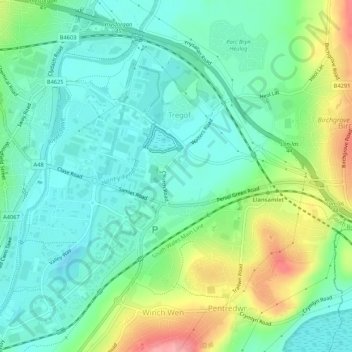
Naam: Topografische kaart Llansamlet, hoogte, reliëf.
Locatie: Llansamlet, Swansea, Wales, United Kingdom (51.64964 -3.92432 51.67639 -3.87105)
Gemiddelde hoogte: 32 m
Minimale hoogte: -4 m
Maximale hoogte: 106 m
Andere topografische kaarten
Klik op een kaart om zijn topografie, zijn hoogte en zijn reliëf te bekijken.
Oxwich
United Kingdom > Wales > Swansea
Oxwich, Swansea, Wales, SA3 1LS, United Kingdom
Gemiddelde hoogte: 36 m
Slade
United Kingdom > Wales > Swansea > Slade
Slade, Swansea, Wales, SA3 1NA, United Kingdom
Gemiddelde hoogte: 36 m
Clydach
United Kingdom > Wales > Swansea > Clydach
Clydach, Swansea, Wales, United Kingdom
Gemiddelde hoogte: 111 m
Morriston
United Kingdom > Wales > Swansea > Morriston
Morriston, Swansea, Wales, SA6 6DR, United Kingdom
Gemiddelde hoogte: 75 m
Swansea
United Kingdom > Wales > Swansea
Swansea, Wales, SA1 3BN, United Kingdom
Gemiddelde hoogte: 73 m
Oxwich
United Kingdom > Wales > Swansea
Oxwich, Penrice, Slade, Oxwich, Swansea, Wales, United Kingdom
Gemiddelde hoogte: 41 m