
Doe een donatie
Rust jezelf uit voor je volgende avontuur:
Als Amazon-partner verdient deze site een commissie op in aanmerking komende aankopen, zonder extra kosten voor jou.
Topografische kaart Brancaster Staithe
Klik op de kaart om de hoogte weer te geven.
Doe een donatie
Rust jezelf uit voor je volgende avontuur:
Als Amazon-partner verdient deze site een commissie op in aanmerking komende aankopen, zonder extra kosten voor jou.
Over deze kaart
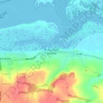
Naam: Topografische kaart Brancaster Staithe, hoogte, reliëf.
Gemiddelde hoogte: 18 m
Minimale hoogte: -1 m
Maximale hoogte: 69 m
Doe een donatie
Rust jezelf uit voor je volgende avontuur:
Als Amazon-partner verdient deze site een commissie op in aanmerking komende aankopen, zonder extra kosten voor jou.
Andere topografische kaarten
Klik op een kaart om zijn topografie, zijn hoogte en zijn reliëf te bekijken.
Ringstead
United Kingdom > England > Norfolk > King's Lynn and West Norfolk > Ringstead
Gemiddelde hoogte: 37 m
Doe een donatie
Rust jezelf uit voor je volgende avontuur:
Als Amazon-partner verdient deze site een commissie op in aanmerking komende aankopen, zonder extra kosten voor jou.
Grimston
United Kingdom > England > Norfolk > King's Lynn and West Norfolk > Grimston
Gemiddelde hoogte: 30 m
Downham Market
United Kingdom > England > Norfolk > King's Lynn and West Norfolk
Gemiddelde hoogte: 20 m
Doe een donatie
Rust jezelf uit voor je volgende avontuur:
Als Amazon-partner verdient deze site een commissie op in aanmerking komende aankopen, zonder extra kosten voor jou.
Terrington St. Clement
United Kingdom > England > Norfolk > King's Lynn and West Norfolk
Gemiddelde hoogte: 2 m
Doe een donatie
Rust jezelf uit voor je volgende avontuur:
Als Amazon-partner verdient deze site een commissie op in aanmerking komende aankopen, zonder extra kosten voor jou.
South Creake
United Kingdom > England > Norfolk > King's Lynn and West Norfolk
Gemiddelde hoogte: 54 m
Doe een donatie
Rust jezelf uit voor je volgende avontuur:
Als Amazon-partner verdient deze site een commissie op in aanmerking komende aankopen, zonder extra kosten voor jou.
North Creake
United Kingdom > England > Norfolk > King's Lynn and West Norfolk
Gemiddelde hoogte: 46 m
Doe een donatie
Rust jezelf uit voor je volgende avontuur:
Als Amazon-partner verdient deze site een commissie op in aanmerking komende aankopen, zonder extra kosten voor jou.
Little Massingham
United Kingdom > England > Norfolk > King's Lynn and West Norfolk
Gemiddelde hoogte: 74 m
Syderstone
United Kingdom > England > Norfolk > King's Lynn and West Norfolk > Syderstone
Gemiddelde hoogte: 60 m
Doe een donatie
Rust jezelf uit voor je volgende avontuur:
Als Amazon-partner verdient deze site een commissie op in aanmerking komende aankopen, zonder extra kosten voor jou.
Hockwold cum Wilton
United Kingdom > England > Norfolk > King's Lynn and West Norfolk
Gemiddelde hoogte: 11 m
Tilney St. Lawrence
United Kingdom > England > Norfolk > King's Lynn and West Norfolk
Gemiddelde hoogte: 2 m
Doe een donatie
Rust jezelf uit voor je volgende avontuur:
Als Amazon-partner verdient deze site een commissie op in aanmerking komende aankopen, zonder extra kosten voor jou.
Great Massingham
United Kingdom > England > Norfolk > King's Lynn and West Norfolk
Gemiddelde hoogte: 79 m
Ingoldisthorpe
United Kingdom > England > Norfolk > King's Lynn and West Norfolk
Gemiddelde hoogte: 22 m
Hunstanton Beach
United Kingdom > England > Norfolk > King's Lynn and West Norfolk > Hunstanton > Old Hunstanton
Gemiddelde hoogte: 10 m
Doe een donatie
Rust jezelf uit voor je volgende avontuur:
Als Amazon-partner verdient deze site een commissie op in aanmerking komende aankopen, zonder extra kosten voor jou.
Castle Rising
United Kingdom > England > Norfolk > King's Lynn and West Norfolk
Gemiddelde hoogte: 20 m
Roydon
United Kingdom > England > Norfolk > King's Lynn and West Norfolk > Roydon
Gemiddelde hoogte: 20 m
Doe een donatie
Rust jezelf uit voor je volgende avontuur:
Als Amazon-partner verdient deze site een commissie op in aanmerking komende aankopen, zonder extra kosten voor jou.
Ely-Ouse-Essex Water Transfer Scheme
United Kingdom > England > Norfolk > King's Lynn and West Norfolk > Hockwold cum Wilton
Gemiddelde hoogte: 4 m
Burnham Overy
United Kingdom > England > Norfolk > King's Lynn and West Norfolk
Gemiddelde hoogte: 6 m
Doe een donatie
Rust jezelf uit voor je volgende avontuur:
Als Amazon-partner verdient deze site een commissie op in aanmerking komende aankopen, zonder extra kosten voor jou.
Northwold
United Kingdom > England > Norfolk > King's Lynn and West Norfolk > Northwold
Gemiddelde hoogte: 12 m
Sandringham Estate
United Kingdom > England > Norfolk > King's Lynn and West Norfolk > Sandringham
Gemiddelde hoogte: 25 m
Walpole Highway
United Kingdom > England > Norfolk > King's Lynn and West Norfolk > Walpole Highway
Gemiddelde hoogte: 2 m
Ryston
United Kingdom > England > Norfolk > King's Lynn and West Norfolk > Fordham
Gemiddelde hoogte: 15 m
Doe een donatie
Rust jezelf uit voor je volgende avontuur:
Als Amazon-partner verdient deze site een commissie op in aanmerking komende aankopen, zonder extra kosten voor jou.
Old Hunstanton
United Kingdom > England > Norfolk > King's Lynn and West Norfolk
Gemiddelde hoogte: 17 m
West Winch
United Kingdom > England > Norfolk > King's Lynn and West Norfolk > West Winch
Gemiddelde hoogte: 7 m
Doe een donatie
Rust jezelf uit voor je volgende avontuur:
Als Amazon-partner verdient deze site een commissie op in aanmerking komende aankopen, zonder extra kosten voor jou.
Burnham Market
United Kingdom > England > Norfolk > King's Lynn and West Norfolk
Gemiddelde hoogte: 44 m
Terrington St. John
United Kingdom > England > Norfolk > King's Lynn and West Norfolk
Gemiddelde hoogte: 2 m
Doe een donatie
Rust jezelf uit voor je volgende avontuur:
Als Amazon-partner verdient deze site een commissie op in aanmerking komende aankopen, zonder extra kosten voor jou.
Docking
United Kingdom > England > Norfolk > King's Lynn and West Norfolk
Docking village in the centre of the parish is situated at an elevation of 82.7 metres (272 feet), which makes it one of the highest in Norfolk. It is surrounded by arable farmland having little woodland and is a nucleated settlement, with only one historical hamlet associated with it. This is Summerfield to…
Gemiddelde hoogte: 63 m
Wiggenhall St. Mary Magdalen
United Kingdom > England > Norfolk > King's Lynn and West Norfolk
Gemiddelde hoogte: 1 m
Doe een donatie
Rust jezelf uit voor je volgende avontuur:
Als Amazon-partner verdient deze site een commissie op in aanmerking komende aankopen, zonder extra kosten voor jou.
Doe een donatie
Rust jezelf uit voor je volgende avontuur:
Als Amazon-partner verdient deze site een commissie op in aanmerking komende aankopen, zonder extra kosten voor jou.
Southery
United Kingdom > England > Norfolk > King's Lynn and West Norfolk > Southery
Gemiddelde hoogte: 0 m
Clenchwarton
United Kingdom > England > Norfolk > King's Lynn and West Norfolk > Clenchwarton
Gemiddelde hoogte: 3 m
Doe een donatie
Rust jezelf uit voor je volgende avontuur:
Als Amazon-partner verdient deze site een commissie op in aanmerking komende aankopen, zonder extra kosten voor jou.
Old Bedford River
United Kingdom > England > Norfolk > King's Lynn and West Norfolk
Gemiddelde hoogte: 1 m
Doe een donatie
Rust jezelf uit voor je volgende avontuur:
Als Amazon-partner verdient deze site een commissie op in aanmerking komende aankopen, zonder extra kosten voor jou.
Holme next the Sea
United Kingdom > England > Norfolk > King's Lynn and West Norfolk
Gemiddelde hoogte: 10 m
Tilney All Saints
United Kingdom > England > Norfolk > King's Lynn and West Norfolk
Gemiddelde hoogte: 3 m
Doe een donatie
Rust jezelf uit voor je volgende avontuur:
Als Amazon-partner verdient deze site een commissie op in aanmerking komende aankopen, zonder extra kosten voor jou.
Bawsey
United Kingdom > England > Norfolk > King's Lynn and West Norfolk > Bawsey
Gemiddelde hoogte: 16 m
Saint Hilary Park
United Kingdom > England > Norfolk > King's Lynn and West Norfolk > King's Lynn
Gemiddelde hoogte: 7 m
Wiggenhall St. Germans
United Kingdom > England > Norfolk > King's Lynn and West Norfolk
Gemiddelde hoogte: 3 m
Doe een donatie
Rust jezelf uit voor je volgende avontuur:
Als Amazon-partner verdient deze site een commissie op in aanmerking komende aankopen, zonder extra kosten voor jou.
South Wootton
United Kingdom > England > Norfolk > King's Lynn and West Norfolk
Gemiddelde hoogte: 11 m
Castle Rising
United Kingdom > England > Norfolk > King's Lynn and West Norfolk > Castle Rising
Gemiddelde hoogte: 22 m
North Runcton
United Kingdom > England > Norfolk > King's Lynn and West Norfolk
Gemiddelde hoogte: 12 m
Doe een donatie
Rust jezelf uit voor je volgende avontuur:
Als Amazon-partner verdient deze site een commissie op in aanmerking komende aankopen, zonder extra kosten voor jou.
West Winch
United Kingdom > England > Norfolk > King's Lynn and West Norfolk > West Winch
Gemiddelde hoogte: 7 m
Walpole Highway
United Kingdom > England > Norfolk > King's Lynn and West Norfolk > Walpole Highway
Gemiddelde hoogte: 2 m
Doe een donatie
Rust jezelf uit voor je volgende avontuur:
Als Amazon-partner verdient deze site een commissie op in aanmerking komende aankopen, zonder extra kosten voor jou.
Docking
United Kingdom > England > Norfolk > King's Lynn and West Norfolk
Docking village in the centre of the parish is situated at an elevation of 82.7 metres (272 feet), which makes it one of the highest in Norfolk. It is surrounded by arable farmland having little woodland and is a nucleated settlement, with only one historical hamlet associated with it. This is Summerfield to…
Gemiddelde hoogte: 63 m
Great Massingham
United Kingdom > England > Norfolk > King's Lynn and West Norfolk
Gemiddelde hoogte: 79 m
Doe een donatie
Rust jezelf uit voor je volgende avontuur:
Als Amazon-partner verdient deze site een commissie op in aanmerking komende aankopen, zonder extra kosten voor jou.