
Topografische kaart Rattlesnake Wilderness
Interactieve kaart
Klik op de kaart om de hoogte weer te geven.
Over deze kaart
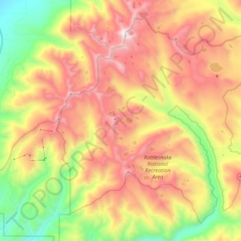
Naam: Topografische kaart Rattlesnake Wilderness, hoogte, reliëf.
Gemiddelde hoogte: 1.847 m
Minimale hoogte: 1.070 m
Maximale hoogte: 2.622 m
Andere topografische kaarten
Klik op een kaart om zijn topografie, zijn hoogte en zijn reliëf te bekijken.
Missoula
United States > Montana > Missoula County
Missoula, Missoula County, Montana, United States
Gemiddelde hoogte: 1.173 m
Franklin Park
United States > Montana > Missoula County > Missoula
Franklin Park, Franklin to the Fort, Missoula, Missoula County, Montana, United States
Gemiddelde hoogte: 968 m
Riata Park
United States > Montana > Missoula County > Missoula
Riata Park, 44 Ranch, Orchard Homes, Missoula, Missoula County, Montana, United States
Gemiddelde hoogte: 961 m
Seeley Lake
United States > Montana > Missoula County
Seeley Lake, Missoula County, Montana, United States
Gemiddelde hoogte: 1.348 m
Lolo
United States > Montana > Missoula County > Lolo
Lolo, Missoula County, Montana, United States
Gemiddelde hoogte: 1.077 m